ਤਸਵੀਰ:Historic pakistan rel96b.JPG

ਇਸ ਝਾਤ ਦਾ ਅਕਾਰ: 497 × 600 ਪਿਕਸਲ. ਹੋਰ ਰੈਜ਼ੋਲਿਊਸ਼ਨਜ਼: 199 × 240 ਪਿਕਸਲ | 398 × 480 ਪਿਕਸਲ | 636 × 768 ਪਿਕਸਲ | 1,104 × 1,332 ਪਿਕਸਲ.
ਅਸਲ ਫ਼ਾਈਲ (1,104 × 1,332 ਪਿਕਸਲ, ਫ਼ਾਈਲ ਅਕਾਰ: 357 KB, MIME ਕਿਸਮ: image/jpeg)
ਸਾਰ
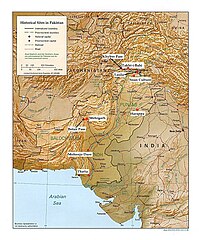
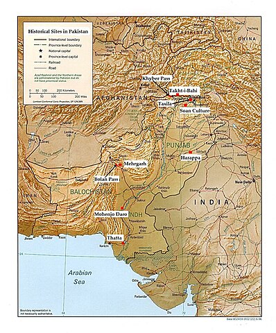
| ਵੇਰਵਾ | This is an annotated version of a relief map of Pakistan in the public domain([1]). The map was annotated by Fowler&fowler«Talk» 22:23, 10 March 2007 (UTC) and rereleased to the public domain. |
| ਮਿਤੀ | 10 ਮਾਰਚ 2007 (original upload date) |
| ਸਰੋਤ | Transferred from en.wikipedia to Commons. |
| ਲਿਖਾਰੀ | Fowler&fowler at ਅੰਗਰੇਜ਼ੀ ਵਿਕੀਪੀਡੀਆ |
ਲਸੰਸ
| This work has been released into the public domain by its author, Fowler&fowler at ਅੰਗਰੇਜ਼ੀ ਵਿਕੀਪੀਡੀਆ. This applies worldwide. In some countries this may not be legally possible; if so: Fowler&fowler grants anyone the right to use this work for any purpose, without any conditions, unless such conditions are required by law. |
Original upload log
The original description page was here. All following user names refer to en.wikipedia.
- 2007-03-10 22:23 Fowler&fowler 1104×1332×8 (365614 bytes) == Summary == This is an annotated version of a relief map of Pakistan in the public domain([http://www.lib.utexas.edu/maps/faq.html]). The map was annotated by ~~~~ and rereleased to the public domain. {{PD-self}}
ਫ਼ਾਈਲ ਦਾ ਅਤੀਤ
ਤਾਰੀਖ/ਸਮੇਂ ’ਤੇ ਕਲਿੱਕ ਕਰੋ ਤਾਂ ਉਸ ਸਮੇਂ ਦੀ ਫਾਈਲ ਪੇਸ਼ ਹੋ ਜਾਵੇਗੀ।
| ਮਿਤੀ/ਸਮਾਂ | ਨਮੂਨਾ | ਨਾਪ | ਵਰਤੋਂਕਾਰ | ਟਿੱਪਣੀ | |
|---|---|---|---|---|---|
| ਮੌਜੂਦਾ | 19:53, 22 ਸਤੰਬਰ 2007 | | 1,104 × 1,332 (357 KB) | A3A3A3A | {{Information |Description=This is an annotated version of a relief map of Pakistan in the public domain([http://www.lib.utexas.edu/maps/faq.html]). The map was annotated by <font color="#B8860B">Fowler&fowler</font>[[:en:User |
ਫ਼ਾਈਲ ਦੀ ਵਰਤੋਂ
ਇਹ ਫਾਈਲ ਹੇਠਾਂ ਦਿੱਤਾ ਸਫ਼ਾ ਵਰਤਦਾ ਹੈ:
ਫ਼ਾਈਲ ਦੀ ਵਿਆਪਕ ਵਰਤੋਂ
ਇਸ ਫ਼ਾਈਲ ਨੂੰ ਹੋਰ ਹੇਠ ਲਿਖੇ ਵਿਕੀ ਵਰਤਦੇ ਹਨ:
- ast.wikipedia.org ਉੱਤੇ ਵਰਤੋਂ
- bn.wikipedia.org ਉੱਤੇ ਵਰਤੋਂ
- bpy.wikipedia.org ਉੱਤੇ ਵਰਤੋਂ
- br.wikipedia.org ਉੱਤੇ ਵਰਤੋਂ
- ca.wikipedia.org ਉੱਤੇ ਵਰਤੋਂ
- ckb.wikipedia.org ਉੱਤੇ ਵਰਤੋਂ
- da.wikipedia.org ਉੱਤੇ ਵਰਤੋਂ
- en.wikipedia.org ਉੱਤੇ ਵਰਤੋਂ
- es.wikipedia.org ਉੱਤੇ ਵਰਤੋਂ
- ka.wikipedia.org ਉੱਤੇ ਵਰਤੋਂ
- ml.wikipedia.org ਉੱਤੇ ਵਰਤੋਂ
- no.wikipedia.org ਉੱਤੇ ਵਰਤੋਂ
- sq.wikipedia.org ਉੱਤੇ ਵਰਤੋਂ
- ta.wikipedia.org ਉੱਤੇ ਵਰਤੋਂ
- vi.wikipedia.org ਉੱਤੇ ਵਰਤੋਂ
- xmf.wikipedia.org ਉੱਤੇ ਵਰਤੋਂ