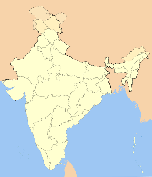
ਤਸਵੀਰ:India-locator-map-blank.svg

Size of this PNG preview of this SVG file: 514 × 600 ਪਿਕਸਲ. ਹੋਰ ਰੈਜ਼ੋਲਿਊਸ਼ਨਜ਼: 206 × 240 ਪਿਕਸਲ | 411 × 480 ਪਿਕਸਲ | 658 × 768 ਪਿਕਸਲ | 877 × 1,024 ਪਿਕਸਲ | 1,755 × 2,048 ਪਿਕਸਲ | 1,486 × 1,734 ਪਿਕਸਲ.
ਅਸਲ ਫ਼ਾਈਲ (SVG ਫ਼ਾਈਲ, ਆਮ ਤੌਰ ’ਤੇ 1,486 × 1,734 ਪਿਕਸਲ, ਫ਼ਾਈਲ ਦਾ ਅਕਾਰ: 252 KB)
ਫ਼ਾਈਲ ਦਾ ਅਤੀਤ
ਤਾਰੀਖ/ਸਮੇਂ ’ਤੇ ਕਲਿੱਕ ਕਰੋ ਤਾਂ ਉਸ ਸਮੇਂ ਦੀ ਫਾਈਲ ਪੇਸ਼ ਹੋ ਜਾਵੇਗੀ।
| ਮਿਤੀ/ਸਮਾਂ | ਨਮੂਨਾ | ਨਾਪ | ਵਰਤੋਂਕਾਰ | ਟਿੱਪਣੀ | |
|---|---|---|---|---|---|
| ਮੌਜੂਦਾ | 14:01, 14 ਅਕਤੂਬਰ 2020 |  | 1,486 × 1,734 (252 KB) | NordNordWest | upd Telangana/Andhra Pradesh |
| 17:48, 25 ਜੁਲਾਈ 2020 |  | 1,486 × 1,734 (252 KB) | NordNordWest | Jammu and Kashmir/Ladakh | |
| 01:42, 1 ਅਪਰੈਲ 2017 |  | 1,486 × 1,734 (337 KB) | Utcursch | Moved Telangana to states layer | |
| 14:08, 29 ਜਨਵਰੀ 2016 |  | 1,486 × 1,734 (379 KB) | Csyogi | Telangana update | |
| 15:36, 16 ਮਈ 2006 |  | 1,486 × 1,734 (421 KB) | Nichalp | Siachen edits | |
| 12:49, 13 ਮਈ 2006 |  | 1,486 × 1,734 (424 KB) | Nichalp | Siachen correction | |
| 12:43, 13 ਮਈ 2006 |  | 1,486 × 1,734 (422 KB) | Nichalp | border changes | |
| 05:53, 9 ਮਈ 2006 |  | 1,486 × 1,734 (421 KB) | Nichalp | Updates as suggested in FPC | |
| 07:48, 7 ਮਈ 2006 |  | 1,486 × 1,734 (421 KB) | Nichalp | Version 2; added some additional disputed areas in the Western sector | |
| 18:27, 6 ਮਈ 2006 |  | 1,486 × 1,734 (416 KB) | Nichalp | Blank locator map of India SVG Map drawn by me, ~~~~ category:Maps of India |
ਫ਼ਾਈਲ ਦੀ ਵਰਤੋਂ
ਇਹ ਫਾਈਲ ਹੇਠਾਂ ਦਿੱਤੇ 4 ਸਫ਼ੇ ਵਰਤਦੇ ਹਨ:
ਫ਼ਾਈਲ ਦੀ ਵਿਆਪਕ ਵਰਤੋਂ
ਇਸ ਫ਼ਾਈਲ ਨੂੰ ਹੋਰ ਹੇਠ ਲਿਖੇ ਵਿਕੀ ਵਰਤਦੇ ਹਨ:
- as.wikipedia.org ਉੱਤੇ ਵਰਤੋਂ
- as.wikiquote.org ਉੱਤੇ ਵਰਤੋਂ
- awa.wikipedia.org ਉੱਤੇ ਵਰਤੋਂ
- खाँचा:ज्ञानसन्दूक भारत कय क्षेत्र
- भारत कय राज्य
- भारत कय संघ राज्यक्षेत्र
- खाँचा:India States and Territories Labelled Map
- खाँचा:Infobox Indian Jurisdiction
- खाँचा:Infobox Indian Jurisdiction/Examples/city
- खाँचा:Infobox Indian Jurisdiction/Examples/district
- खाँचा:Infobox Indian Jurisdiction/Examples/neighbourhood
- खाँचा:Infobox Indian Jurisdiction/Examples/protected area
- खाँचा:Infobox Indian Jurisdiction/Examples/state
- खाँचा:Infobox Indian Jurisdiction/Examples/suburb
- खाँचा:Infobox Indian Jurisdiction/Examples/town
- खाँचा:Infobox Indian Jurisdiction/Examples/village
- खाँचा:Infobox Indian Jurisdiction/Sandbox
- खाँचा:Infobox Indian Jurisdiction/Sandbox/doc
- खाँचा:Infobox Indian Jurisdiction/doc
- खाँचा:ज्ञानसन्दूक भारत कय क्षेत्र/doc
- सीधी
- ban.wikipedia.org ਉੱਤੇ ਵਰਤੋਂ
- bn.wikipedia.org ਉੱਤੇ ਵਰਤੋਂ
- bpy.wikipedia.org ਉੱਤੇ ਵਰਤੋਂ
ਇਸ ਫ਼ਾਈਲ ਦੀ ਹੋਰ ਵਿਆਪਕ ਵਰਤੋਂ ਵੇਖੋ।

