ਤਸਵੀਰ:Albania District.svg

Size of this PNG preview of this SVG file: 304 × 600 ਪਿਕਸਲ. ਹੋਰ ਰੈਜ਼ੋਲਿਊਸ਼ਨਜ਼: 121 × 240 ਪਿਕਸਲ | 243 × 480 ਪਿਕਸਲ | 389 × 768 ਪਿਕਸਲ | 519 × 1,024 ਪਿਕਸਲ | 1,038 × 2,048 ਪਿਕਸਲ | 508 × 1,002 ਪਿਕਸਲ.
ਅਸਲ ਫ਼ਾਈਲ (SVG ਫ਼ਾਈਲ, ਆਮ ਤੌਰ ’ਤੇ 508 × 1,002 ਪਿਕਸਲ, ਫ਼ਾਈਲ ਦਾ ਅਕਾਰ: 276 KB)
| ਵੇਰਵਾ |
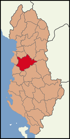
English: Albania location Tirana County.
Blank map of the districts of Albania, useful for numbering/labelling for other languages. |
||
| ਮਿਤੀ | (UTC) | ||
| ਸਰੋਤ | |||
| ਲਿਖਾਰੀ |
|
||
| SVG genesis | This W3C-invalid map was created with Adobe Illustrator.
|
ਇਸ ਫ਼ਾਈਲ ਦਾ ਲਸੰਸ ਕ੍ਰਿਏਟਿਵ ਕਾਮਨਜ਼ ਐਟ੍ਰੀਬਿਊਸ਼ਨ-ਸ਼ੇਅਰ ਅਲਾਈਕ 3.0 ਅਨਪੋਰਟੇਡ ਹੈ।
- ਤੁਹਾਨੂੰ ਖੁੱਲ੍ਹ ਹੈ:
- ਸਾਂਝਾ ਕਰਨ ਦੀ – ਰਚਨਾ ਨੂੰ ਕਾਪੀ, ਵੰਡਣਾ ਅਤੇ ਭੇਜਣਾ
- ਮੁੜ-ਰਲ਼ਾਉਣ ਦੀ – ਰਚਨਾ ਨੂੰ ਢਾਲਣਾ
- ਥੱਲੇ ਲਿਖੀਆਂ ਸ਼ਰਤਾਂ ਹੇਠ:
- ਗੁਣਾਂ ਦੀ ਦੱਸ – ਉਚਿਤ ਕ੍ਰੈਡਿਟ ਦੇਵੋ, ਲਾਇਸੰਸ ਦਾ ਇੱਕ ਲਿੰਕ ਪ੍ਰਦਾਨ ਕਰੋ ਅਤੇ ਇਹ ਦਰਸਾਓ ਕਿ ਕੀ ਤਬਦੀਲੀਆਂ ਕੀਤੀਆਂ ਗਈਆਂ ਸਨ। ਤੁਸੀਂ ਇਹ ਕਿਸੇ ਵੀ ਵਾਜਬ ਤਰੀਕੇ ਨਾਲ ਕਰ ਸਕਦੇ ਹੋ, ਪਰ ਇਹ ਤਰੀਕਾ ਅਜਿਹਾ ਨਹੀਂ ਹੋਣਾ ਚਾਹੀਦਾ ਜੋ ਇਹ ਦਰਸਾਵੇ ਕਿ ਲਾਇਸੰਸਕਰਤਾ ਤੁਹਾਨੂੰ ਜਾਂ ਤੁਹਾਡੀ ਵਰਤੋਂ ਦਾ ਸਮਰਥਨ ਕਰਦਾ ਹੈ।
- ਸ਼ੇਅਰ ਅਲਾਈਕ – ਜੇਕਰ ਤੁਸੀਂ ਸਮੱਗਰੀ ਨੂੰ ਰੀਮਿਕਸ ਕਰਦੇ ਹੋ, ਬਦਲਦੇ ਹੋ ਜਾਂ ਬਣਾਉਂਦੇ ਹੋ, ਤਾਂ ਆਪਣੇ ਯੋਗਦਾਨ ਇੱਕੋ ਜਿਹੇ ਜਾਂ ਅਨੁਕੂਲ ਲਾਇਸੰਸ ਦੇ ਅਧੀਨ ਕਰੋ।
Original upload log
This image is a derivative work of the following images:
- File:Albania location Tirana.svg licensed with Cc-by-3.0
- 2010-03-30T16:55:33Z The Emirr 508x1002 (201332 Bytes) {{Information |Description={{en|1=Albania location Tirana County.}} |Source={{own}} |Author={{click|image=TheEmirr-Logo.png|link=User:The Emirr|width=60px|height=60px}} |Date=2010-03-30 |Permission={{The Emirr}} |other_versio
- File:Albania districts.svg licensed with Cc-by-2.5, Cc-by-sa-3.0-migrated, GFDL
- 2011-05-07T19:36:03Z Malyszkz 1000x2112 (113600 Bytes) change border size
- 2011-05-07T18:46:45Z Malyszkz 1000x2112 (113609 Bytes) {{Information |Description=Blank map of the districts of Albania, useful for numbering/labelling for other languages. |Source=*[[:File:Albania_districts_blank_2.svg|]] |Date=2011-05-07 18:46 (UTC) |Author=*[[:File:Albania_dis
Uploaded with derivativeFX
ਫ਼ਾਈਲ ਦਾ ਅਤੀਤ
ਤਾਰੀਖ/ਸਮੇਂ ’ਤੇ ਕਲਿੱਕ ਕਰੋ ਤਾਂ ਉਸ ਸਮੇਂ ਦੀ ਫਾਈਲ ਪੇਸ਼ ਹੋ ਜਾਵੇਗੀ।
| ਮਿਤੀ/ਸਮਾਂ | ਨਮੂਨਾ | ਨਾਪ | ਵਰਤੋਂਕਾਰ | ਟਿੱਪਣੀ | |
|---|---|---|---|---|---|
| ਮੌਜੂਦਾ | 12:18, 8 ਮਈ 2011 | | 508 × 1,002 (276 KB) | Vinie007 | color fix |
| 12:00, 8 ਮਈ 2011 |  | 508 × 1,002 (276 KB) | Malyszkz | {{Information |Description={{en|1=Albania location Tirana County.}} Blank map of the districts of Albania, useful for numbering/labelling for other languages. |Source=*File:Albania_location_Tirana.svg *File:Albania_districts.svg |Date=2011-05- |
ਫ਼ਾਈਲ ਦੀ ਵਰਤੋਂ
ਇਹ ਫਾਈਲ ਹੇਠਾਂ ਦਿੱਤਾ ਸਫ਼ਾ ਵਰਤਦਾ ਹੈ:
ਫ਼ਾਈਲ ਦੀ ਵਿਆਪਕ ਵਰਤੋਂ
ਇਸ ਫ਼ਾਈਲ ਨੂੰ ਹੋਰ ਹੇਠ ਲਿਖੇ ਵਿਕੀ ਵਰਤਦੇ ਹਨ:
- dv.wikipedia.org ਉੱਤੇ ਵਰਤੋਂ
- en.wikipedia.org ਉੱਤੇ ਵਰਤੋਂ
- fa.wikipedia.org ਉੱਤੇ ਵਰਤੋਂ
- incubator.wikimedia.org ਉੱਤੇ ਵਰਤੋਂ
- lt.wikipedia.org ਉੱਤੇ ਵਰਤੋਂ
- nap.wikipedia.org ਉੱਤੇ ਵਰਤੋਂ
- pnt.wikipedia.org ਉੱਤੇ ਵਰਤੋਂ
- rm.wikipedia.org ਉੱਤੇ ਵਰਤੋਂ
- ru.wikipedia.org ਉੱਤੇ ਵਰਤੋਂ
- sco.wikipedia.org ਉੱਤੇ ਵਰਤੋਂ
- simple.wikipedia.org ਉੱਤੇ ਵਰਤੋਂ
- sq.wikipedia.org ਉੱਤੇ ਵਰਤੋਂ
- sr.wikipedia.org ਉੱਤੇ ਵਰਤੋਂ
- ti.wikipedia.org ਉੱਤੇ ਵਰਤੋਂ
- vi.wikipedia.org ਉੱਤੇ ਵਰਤੋਂ