ਤਸਵੀਰ:Almoravid map reconquest loc.jpg
ਇਸ ਤੋਂ ਵੱਡੀ ਤਸਵੀਰ ਮੌਜੂਦ ਨਹੀਂ ਹੈ।
Almoravid_map_reconquest_loc.jpg (501 × 422 ਪਿਕਸਲ, ਫ਼ਾਈਲ ਅਕਾਰ: 49 KB, MIME ਕਿਸਮ: image/jpeg)
ਸਾਰ
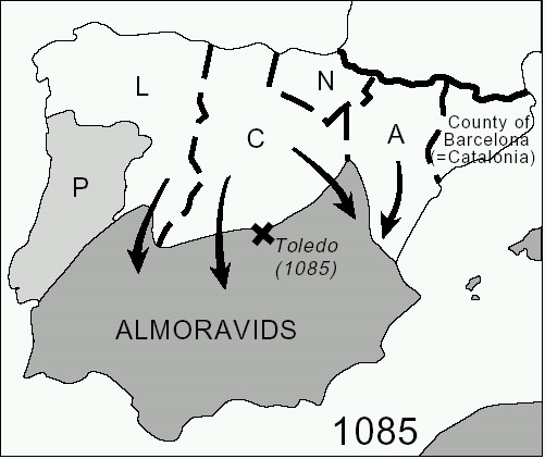
Map of Spain under Almoravides, 1085 Detail of pdf image:http://lcweb2.loc.gov/frd/cs/spain/es01_04a.pdf
Originally from a The Library of COngress Country Study on Spain
A) Aragón
C) Castile
L) Leon
N) Navarre
P) Portugal
X-battle


ਲਸੰਸ
This work is in the public domain in the United States because it is a work prepared by an officer or employee of the United States Government as part of that person’s official duties under the terms of Title 17, Chapter 1, Section 105 of the US Code.
Note: This only applies to original works of the Federal Government and not to the work of any individual U.S. state, territory, commonwealth, county, municipality, or any other subdivision. This template also does not apply to postage stamp designs published by the United States Postal Service since 1978. (See § 313.6(C)(1) of Compendium of U.S. Copyright Office Practices). It also does not apply to certain US coins; see The US Mint Terms of Use.
|
 | |
| This file has been identified as being free of known restrictions under copyright law, including all related and neighboring rights. | ||
ਫ਼ਾਈਲ ਦਾ ਅਤੀਤ
ਤਾਰੀਖ/ਸਮੇਂ ’ਤੇ ਕਲਿੱਕ ਕਰੋ ਤਾਂ ਉਸ ਸਮੇਂ ਦੀ ਫਾਈਲ ਪੇਸ਼ ਹੋ ਜਾਵੇਗੀ।
| ਮਿਤੀ/ਸਮਾਂ | ਨਮੂਨਾ | ਨਾਪ | ਵਰਤੋਂਕਾਰ | ਟਿੱਪਣੀ | |
|---|---|---|---|---|---|
| ਮੌਜੂਦਾ | 22:34, 24 ਜਨਵਰੀ 2006 | | 501 × 422 (49 KB) | Bkwillwm | Category:Reconquista Category:LOC Wikiproject Map of Spain under Almoravides, 1085 Detail of pdf image:http://lcweb2.loc.gov/frd/cs/spain/es01_04a.pdf Originally from a The Library of COngress Country Study on Spain |
ਫ਼ਾਈਲ ਦੀ ਵਰਤੋਂ
ਇਹ ਫਾਈਲ ਹੇਠਾਂ ਦਿੱਤਾ ਸਫ਼ਾ ਵਰਤਦਾ ਹੈ:
ਫ਼ਾਈਲ ਦੀ ਵਿਆਪਕ ਵਰਤੋਂ
ਇਸ ਫ਼ਾਈਲ ਨੂੰ ਹੋਰ ਹੇਠ ਲਿਖੇ ਵਿਕੀ ਵਰਤਦੇ ਹਨ:
- az.wikipedia.org ਉੱਤੇ ਵਰਤੋਂ
- ba.wikipedia.org ਉੱਤੇ ਵਰਤੋਂ
- el.wikipedia.org ਉੱਤੇ ਵਰਤੋਂ
- es.wikipedia.org ਉੱਤੇ ਵਰਤੋਂ
- fa.wikipedia.org ਉੱਤੇ ਵਰਤੋਂ
- fr.wikipedia.org ਉੱਤੇ ਵਰਤੋਂ
- gl.wikipedia.org ਉੱਤੇ ਵਰਤੋਂ
- hr.wikipedia.org ਉੱਤੇ ਵਰਤੋਂ
- hy.wikipedia.org ਉੱਤੇ ਵਰਤੋਂ
- hyw.wikipedia.org ਉੱਤੇ ਵਰਤੋਂ
- lt.wikipedia.org ਉੱਤੇ ਵਰਤੋਂ
- nl.wikipedia.org ਉੱਤੇ ਵਰਤੋਂ
- nn.wikipedia.org ਉੱਤੇ ਵਰਤੋਂ
- pnb.wikipedia.org ਉੱਤੇ ਵਰਤੋਂ
- pt.wikipedia.org ਉੱਤੇ ਵਰਤੋਂ
- ru.wikipedia.org ਉੱਤੇ ਵਰਤੋਂ
- sr.wikipedia.org ਉੱਤੇ ਵਰਤੋਂ
- zh.wikipedia.org ਉੱਤੇ ਵਰਤੋਂ