ਤਸਵੀਰ:Calcareous Soil Profile, Seven Sisters Country Park - geograph.org.uk - 1280181.jpg
ਇਸ ਤੋਂ ਵੱਡੀ ਤਸਵੀਰ ਮੌਜੂਦ ਨਹੀਂ ਹੈ।
Calcareous_Soil_Profile,_Seven_Sisters_Country_Park_-_geograph.org.uk_-_1280181.jpg (640 × 430 ਪਿਕਸਲ, ਫ਼ਾਈਲ ਅਕਾਰ: 70 KB, MIME ਕਿਸਮ: image/jpeg)
ਸਾਰ
| ਵੇਰਵਾ |
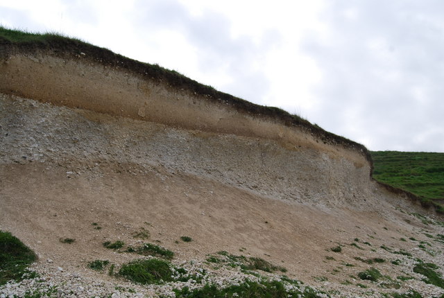
English: Calcareous Soil Profile, Seven Sisters Country Park A well defined soil profile on chalk.
The dark organic ricn humus layer can clearly be seen at the top of the profile. below it is a bleached horizon where nutrients have been leached out & below this is a darker reddish layer of redeposition. At the base of the profile is the weathered bedrock (chalk)the unweathered chalk is hidden. This soil profile is a Rendzina Rendzina |
| ਮਿਤੀ | |
| ਸਰੋਤ | From geograph.org.uk |
| ਲਿਖਾਰੀ | Nigel Chadwick |
| Camera location | | View this and other nearby images on: OpenStreetMap |
|---|
_heading:135.00&language=pa)
| Object location | | View this and other nearby images on: OpenStreetMap |
|---|
_heading:135.00&language=pa)
ਲਸੰਸ

|
This image was taken from the Geograph project collection. See this photograph's page on the Geograph website for the photographer's contact details. The copyright on this image is owned by Nigel Chadwick and is licensed for reuse under the Creative Commons Attribution-ShareAlike 2.0 license.
|
This file is licensed under the Creative Commons Attribution-Share Alike 2.0 Generic license.
ਐਟਰੀਬਿਊਸ਼ਨ: Nigel Chadwick
- ਤੁਹਾਨੂੰ ਖੁੱਲ੍ਹ ਹੈ:
- ਸਾਂਝਾ ਕਰਨ ਦੀ – ਰਚਨਾ ਨੂੰ ਕਾਪੀ, ਵੰਡਣਾ ਅਤੇ ਭੇਜਣਾ
- ਮੁੜ-ਰਲ਼ਾਉਣ ਦੀ – ਰਚਨਾ ਨੂੰ ਢਾਲਣਾ
- ਥੱਲੇ ਲਿਖੀਆਂ ਸ਼ਰਤਾਂ ਹੇਠ:
- ਗੁਣਾਂ ਦੀ ਦੱਸ – ਉਚਿਤ ਕ੍ਰੈਡਿਟ ਦੇਵੋ, ਲਾਇਸੰਸ ਦਾ ਇੱਕ ਲਿੰਕ ਪ੍ਰਦਾਨ ਕਰੋ ਅਤੇ ਇਹ ਦਰਸਾਓ ਕਿ ਕੀ ਤਬਦੀਲੀਆਂ ਕੀਤੀਆਂ ਗਈਆਂ ਸਨ। ਤੁਸੀਂ ਇਹ ਕਿਸੇ ਵੀ ਵਾਜਬ ਤਰੀਕੇ ਨਾਲ ਕਰ ਸਕਦੇ ਹੋ, ਪਰ ਇਹ ਤਰੀਕਾ ਅਜਿਹਾ ਨਹੀਂ ਹੋਣਾ ਚਾਹੀਦਾ ਜੋ ਇਹ ਦਰਸਾਵੇ ਕਿ ਲਾਇਸੰਸਕਰਤਾ ਤੁਹਾਨੂੰ ਜਾਂ ਤੁਹਾਡੀ ਵਰਤੋਂ ਦਾ ਸਮਰਥਨ ਕਰਦਾ ਹੈ।
- ਸ਼ੇਅਰ ਅਲਾਈਕ – ਜੇਕਰ ਤੁਸੀਂ ਸਮੱਗਰੀ ਨੂੰ ਰੀਮਿਕਸ ਕਰਦੇ ਹੋ, ਬਦਲਦੇ ਹੋ ਜਾਂ ਬਣਾਉਂਦੇ ਹੋ, ਤਾਂ ਆਪਣੇ ਯੋਗਦਾਨ ਇੱਕੋ ਜਿਹੇ ਜਾਂ ਅਨੁਕੂਲ ਲਾਇਸੰਸ ਦੇ ਅਧੀਨ ਕਰੋ।
ਫ਼ਾਈਲ ਦਾ ਅਤੀਤ
ਤਾਰੀਖ/ਸਮੇਂ ’ਤੇ ਕਲਿੱਕ ਕਰੋ ਤਾਂ ਉਸ ਸਮੇਂ ਦੀ ਫਾਈਲ ਪੇਸ਼ ਹੋ ਜਾਵੇਗੀ।
| ਮਿਤੀ/ਸਮਾਂ | ਨਮੂਨਾ | ਨਾਪ | ਵਰਤੋਂਕਾਰ | ਟਿੱਪਣੀ | |
|---|---|---|---|---|---|
| ਮੌਜੂਦਾ | 05:41, 27 ਫ਼ਰਵਰੀ 2011 | | 640 × 430 (70 KB) | GeographBot | == {{int:filedesc}} == {{Information |description={{en|1=Calcareous Soil Profile, Seven Sisters Country Park A well defined soil profile on chalk. The dark organic ricn humus layer can clearly be seen at the top of the profile. below it is a bleached hor |
ਫ਼ਾਈਲ ਦੀ ਵਰਤੋਂ
ਇਹ ਫਾਈਲ ਹੇਠਾਂ ਦਿੱਤਾ ਸਫ਼ਾ ਵਰਤਦਾ ਹੈ:
ਫ਼ਾਈਲ ਦੀ ਵਿਆਪਕ ਵਰਤੋਂ
ਇਸ ਫ਼ਾਈਲ ਨੂੰ ਹੋਰ ਹੇਠ ਲਿਖੇ ਵਿਕੀ ਵਰਤਦੇ ਹਨ:
- ar.wikipedia.org ਉੱਤੇ ਵਰਤੋਂ
- bn.wikipedia.org ਉੱਤੇ ਵਰਤੋਂ
- cy.wikipedia.org ਉੱਤੇ ਵਰਤੋਂ
- de.wikipedia.org ਉੱਤੇ ਵਰਤੋਂ
- en.wikipedia.org ਉੱਤੇ ਵਰਤੋਂ
- es.wikipedia.org ਉੱਤੇ ਵਰਤੋਂ
- fa.wikipedia.org ਉੱਤੇ ਵਰਤੋਂ
- fi.wikipedia.org ਉੱਤੇ ਵਰਤੋਂ
- ha.wikipedia.org ਉੱਤੇ ਵਰਤੋਂ
- la.wikipedia.org ਉੱਤੇ ਵਰਤੋਂ
- mk.wikipedia.org ਉੱਤੇ ਵਰਤੋਂ
- si.wikipedia.org ਉੱਤੇ ਵਰਤੋਂ
- zh-yue.wikipedia.org ਉੱਤੇ ਵਰਤੋਂ