ਤਸਵੀਰ:Carte de la Manche.png

ਇਸ ਝਾਤ ਦਾ ਅਕਾਰ: 800 × 447 ਪਿਕਸਲ. ਹੋਰ ਰੈਜ਼ੋਲਿਊਸ਼ਨਜ਼: 320 × 179 ਪਿਕਸਲ | 832 × 465 ਪਿਕਸਲ.
ਅਸਲ ਫ਼ਾਈਲ (832 × 465 ਪਿਕਸਲ, ਫ਼ਾਈਲ ਅਕਾਰ: 107 KB, MIME ਕਿਸਮ: image/png)
ਸਾਰ
| ਵੇਰਵਾ |
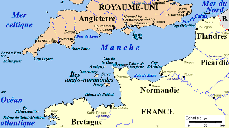
Français : Carte de la Manche avec la situation des caps principaux, des îles et des villes importantes. Projection de Mercator, données de 2005. Fond de carte provenant de [www.aquarius.geomar.de www.aquarius.geomar.de] (défunt).
English: Channel map with main capes, islands and cities. Projection of Mercator, data as of 2005. Map background from [www.aquarius.geomar.de www.aquarius.geomar.de] (defunct). |
| ਮਿਤੀ | 4 ਜੂਨ 2005, 16:52 (original upload date) |
| ਸਰੋਤ | ਆਪਣਾ ਕੰਮ |
| ਲਿਖਾਰੀ | Idarvol (ਗੱਲ-ਬਾਤ · ਯੋਗਦਾਨ) |

|
This map image could be re-created using vector graphics as an SVG file. This has several advantages; see Commons:Media for cleanup for more information. If an SVG form of this image is available, please upload it and afterwards replace this template with
{{vector version available|new image name}}.
It is recommended to name the SVG file “Carte de la Manche.svg”—then the template Vector version available (or Vva) does not need the new image name parameter. |
ਲਸੰਸ
I, the copyright holder of this work, hereby publish it under the following license:

|
ਇਸ ਸਫ਼ੇ ਨੂੰ ਗਨੂ ਲਸੰਸ, ਵਰਜ਼ਨ 1.2 ਜਾਂ ਫਰੀ ਸਾਫਟਵੇਅਰ ਫਾਊਂਡੇਸ਼ਨ ਦੁਆਰਾ ਪ੍ਰਕਾਸ਼ਿਤ ਕੀਤੇ ਨਵੇਂ ਵਰਜ਼ਨ ਤਹਿਤ ਕਾਪੀ ਕਰਨ, ਵੰਡਣ ਜਾਂ/ਅਤੇ ਤਬਦੀਲੀ ਕਰਨ ਦੀ ਖੁੱਲ ਹੈ; ਬਿਨਾ ਕਿਸੇ ਸਥਿਰ ਫਰੰਟ-ਕਵਰ ਜਾਂ ਬੈਕ ਕਵਰ ਲਿਖਤਾਂ ਤੋਂ ਬਿਨਾਂ। ਇਸ ਲਸੰਸ ਦੀ ਇੱਕ ਕਾਪੀ ਇਸ ਗਨੂ ਫਰੀ ਲਸੰਸ ਭਾਗ ਵਿੱਚ ਮੌਜੂਦ ਹੈ। |
| ਇਸ ਫ਼ਾਈਲ ਦਾ ਲਸੰਸ ਕ੍ਰਿਏਟਿਵ ਕਾਮਨਜ਼ ਐਟ੍ਰੀਬਿਊਸ਼ਨ-ਸ਼ੇਅਰ ਅਲਾਈਕ 3.0 ਅਨਪੋਰਟੇਡ ਹੈ। | ||
| ||
| This licensing tag was added to this file as part of the GFDL licensing update. |
ਫ਼ਾਈਲ ਦਾ ਅਤੀਤ
ਤਾਰੀਖ/ਸਮੇਂ ’ਤੇ ਕਲਿੱਕ ਕਰੋ ਤਾਂ ਉਸ ਸਮੇਂ ਦੀ ਫਾਈਲ ਪੇਸ਼ ਹੋ ਜਾਵੇਗੀ।
| ਮਿਤੀ/ਸਮਾਂ | ਨਮੂਨਾ | ਨਾਪ | ਵਰਤੋਂਕਾਰ | ਟਿੱਪਣੀ | |
|---|---|---|---|---|---|
| ਮੌਜੂਦਾ | 17:19, 16 ਨਵੰਬਰ 2020 | | 832 × 465 (107 KB) | Hohum | Cartographic colours |
| 02:40, 3 ਫ਼ਰਵਰੀ 2016 |  | 832 × 465 (99 KB) | Ptyx | Ouesssant > Ouessant | |
| 17:31, 15 ਫ਼ਰਵਰੀ 2011 |  | 832 × 465 (71 KB) | Mahahahaneapneap | Compressed | |
| 16:52, 4 ਜੂਨ 2005 |  | 832 × 465 (105 KB) | Idarvol | Carte de la Manche. |
ਫ਼ਾਈਲ ਦੀ ਵਰਤੋਂ
ਇਹ ਫਾਈਲ ਹੇਠਾਂ ਦਿੱਤਾ ਸਫ਼ਾ ਵਰਤਦਾ ਹੈ:
ਫ਼ਾਈਲ ਦੀ ਵਿਆਪਕ ਵਰਤੋਂ
ਇਸ ਫ਼ਾਈਲ ਨੂੰ ਹੋਰ ਹੇਠ ਲਿਖੇ ਵਿਕੀ ਵਰਤਦੇ ਹਨ:
- af.wikipedia.org ਉੱਤੇ ਵਰਤੋਂ
- br.wikipedia.org ਉੱਤੇ ਵਰਤੋਂ
- bs.wikipedia.org ਉੱਤੇ ਵਰਤੋਂ
- ca.wikipedia.org ਉੱਤੇ ਵਰਤੋਂ
- cs.wikipedia.org ਉੱਤੇ ਵਰਤੋਂ
- de.wikipedia.org ਉੱਤੇ ਵਰਤੋਂ
- en.wikipedia.org ਉੱਤੇ ਵਰਤੋਂ
- es.wikipedia.org ਉੱਤੇ ਵਰਤੋਂ
- fr.wikipedia.org ਉੱਤੇ ਵਰਤੋਂ
- fr.wiktionary.org ਉੱਤੇ ਵਰਤੋਂ
- gd.wikipedia.org ਉੱਤੇ ਵਰਤੋਂ
- hi.wikipedia.org ਉੱਤੇ ਵਰਤੋਂ
- ja.wikipedia.org ਉੱਤੇ ਵਰਤੋਂ
- ka.wikipedia.org ਉੱਤੇ ਵਰਤੋਂ
- kw.wikipedia.org ਉੱਤੇ ਵਰਤੋਂ
- pl.wiktionary.org ਉੱਤੇ ਵਰਤੋਂ
- scn.wikipedia.org ਉੱਤੇ ਵਰਤੋਂ
- sr.wikipedia.org ਉੱਤੇ ਵਰਤੋਂ
- xmf.wikipedia.org ਉੱਤੇ ਵਰਤੋਂ
- zh.wikipedia.org ਉੱਤੇ ਵਰਤੋਂ