ਤਸਵੀਰ:Europe under Nazi domination.png

ਇਸ ਝਾਤ ਦਾ ਅਕਾਰ: 654 × 600 ਪਿਕਸਲ. ਹੋਰ ਰੈਜ਼ੋਲਿਊਸ਼ਨਜ਼: 262 × 240 ਪਿਕਸਲ | 523 × 480 ਪਿਕਸਲ | 837 × 768 ਪਿਕਸਲ | 1,088 × 998 ਪਿਕਸਲ.
ਅਸਲ ਫ਼ਾਈਲ (1,088 × 998 ਪਿਕਸਲ, ਫ਼ਾਈਲ ਅਕਾਰ: 187 KB, MIME ਕਿਸਮ: image/png)

|
File:World War II in Europe, 1942.svg is a vector version of this file. It should be used in place of this PNG file.
File:Europe under Nazi domination.png → File:World War II in Europe, 1942.svg
For more information, see Help:SVG. |
 |
ਸਾਰ
| ਵੇਰਵਾ |
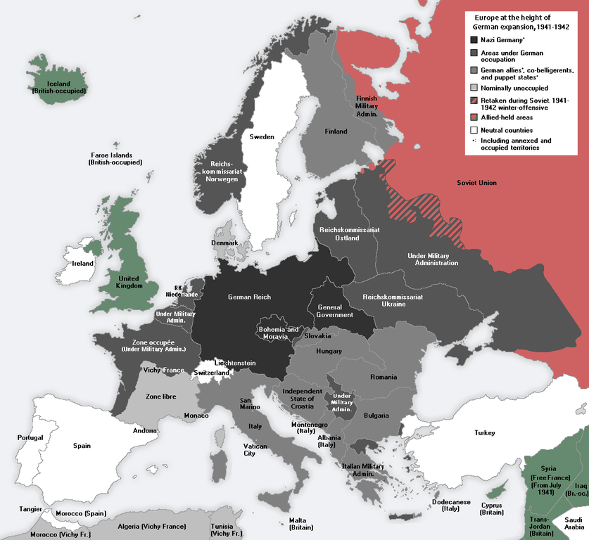
Русский: Европа в разгаре военных завоеваний Оси Второй мировой войны в 1941–1942
English: Europe at the height of the WWII Axis military conquests in 1941–1942.
中文:1941至42年二戰期間,軸心國的軍事佔領達至高峰時的歐洲。 |
| ਮਿਤੀ | |
| ਸਰੋਤ | ਆਪਣਾ ਕੰਮ |
| ਲਿਖਾਰੀ | Morgan Hauser, derived from File:Second world war europe 1943-1945 map en.png and File:Second world war europe 1941-1942 map en.png by users Jarry1250 and ArmadniGeneral, respectively. |
| Other versions |
[]
|


ਲਸੰਸ
I, the copyright holder of this work, hereby publish it under the following license:
ਇਸ ਫ਼ਾਈਲ ਦਾ ਲਸੰਸ ਕ੍ਰਿਏਟਿਵ ਕਾਮਨਜ਼ ਐਟ੍ਰੀਬਿਊਸ਼ਨ-ਸ਼ੇਅਰ ਅਲਾਈਕ 3.0 ਅਨਪੋਰਟੇਡ ਹੈ।
- ਤੁਹਾਨੂੰ ਖੁੱਲ੍ਹ ਹੈ:
- ਸਾਂਝਾ ਕਰਨ ਦੀ – ਰਚਨਾ ਨੂੰ ਕਾਪੀ, ਵੰਡਣਾ ਅਤੇ ਭੇਜਣਾ
- ਮੁੜ-ਰਲ਼ਾਉਣ ਦੀ – ਰਚਨਾ ਨੂੰ ਢਾਲਣਾ
- ਥੱਲੇ ਲਿਖੀਆਂ ਸ਼ਰਤਾਂ ਹੇਠ:
- ਗੁਣਾਂ ਦੀ ਦੱਸ – ਉਚਿਤ ਕ੍ਰੈਡਿਟ ਦੇਵੋ, ਲਾਇਸੰਸ ਦਾ ਇੱਕ ਲਿੰਕ ਪ੍ਰਦਾਨ ਕਰੋ ਅਤੇ ਇਹ ਦਰਸਾਓ ਕਿ ਕੀ ਤਬਦੀਲੀਆਂ ਕੀਤੀਆਂ ਗਈਆਂ ਸਨ। ਤੁਸੀਂ ਇਹ ਕਿਸੇ ਵੀ ਵਾਜਬ ਤਰੀਕੇ ਨਾਲ ਕਰ ਸਕਦੇ ਹੋ, ਪਰ ਇਹ ਤਰੀਕਾ ਅਜਿਹਾ ਨਹੀਂ ਹੋਣਾ ਚਾਹੀਦਾ ਜੋ ਇਹ ਦਰਸਾਵੇ ਕਿ ਲਾਇਸੰਸਕਰਤਾ ਤੁਹਾਨੂੰ ਜਾਂ ਤੁਹਾਡੀ ਵਰਤੋਂ ਦਾ ਸਮਰਥਨ ਕਰਦਾ ਹੈ।
- ਸ਼ੇਅਰ ਅਲਾਈਕ – ਜੇਕਰ ਤੁਸੀਂ ਸਮੱਗਰੀ ਨੂੰ ਰੀਮਿਕਸ ਕਰਦੇ ਹੋ, ਬਦਲਦੇ ਹੋ ਜਾਂ ਬਣਾਉਂਦੇ ਹੋ, ਤਾਂ ਆਪਣੇ ਯੋਗਦਾਨ ਇੱਕੋ ਜਿਹੇ ਜਾਂ ਅਨੁਕੂਲ ਲਾਇਸੰਸ ਦੇ ਅਧੀਨ ਕਰੋ।
ਫ਼ਾਈਲ ਦਾ ਅਤੀਤ
ਤਾਰੀਖ/ਸਮੇਂ ’ਤੇ ਕਲਿੱਕ ਕਰੋ ਤਾਂ ਉਸ ਸਮੇਂ ਦੀ ਫਾਈਲ ਪੇਸ਼ ਹੋ ਜਾਵੇਗੀ।
| ਮਿਤੀ/ਸਮਾਂ | ਨਮੂਨਾ | ਨਾਪ | ਵਰਤੋਂਕਾਰ | ਟਿੱਪਣੀ | |
|---|---|---|---|---|---|
| ਮੌਜੂਦਾ | 11:43, 23 ਜਨਵਰੀ 2015 | | 1,088 × 998 (187 KB) | DIREKTOR | Fixed error in Thrace: Germany occupied a strip of Greek territory at the border with Turkey. |
| 10:54, 22 ਜਨਵਰੀ 2015 |  | 1,088 × 998 (187 KB) | DIREKTOR | Fixed error at Crete. | |
| 09:30, 22 ਜਨਵਰੀ 2015 |  | 1,088 × 998 (187 KB) | DIREKTOR | Added brackets "(Under Military Admin.)", and capitalized "Z" in "zone". | |
| 00:10, 22 ਜਨਵਰੀ 2015 |  | 1,088 × 998 (187 KB) | DIREKTOR | Restored Vichy France label. | |
| 21:46, 21 ਜਨਵਰੀ 2015 |  | 1,088 × 998 (187 KB) | DIREKTOR | Small label fix. | |
| 21:42, 21 ਜਨਵਰੀ 2015 |  | 1,088 × 998 (187 KB) | DIREKTOR | "Reichskommissariat Niederlande" -> "RK Niederlande" | |
| 21:41, 21 ਜਨਵਰੀ 2015 |  | 1,088 × 998 (188 KB) | DIREKTOR | Further fixes and modifications: the Netherlands were not a Nazi co-belligerent: replaced "Netherlands" with "Reichskommissariat Niederlande"; Denmark was not formally occupied by 1941-42; introduced uniform labels for territories under military occupa... | |
| 16:30, 11 ਅਕਤੂਬਰ 2014 |  | 1,088 × 998 (187 KB) | DIREKTOR | "Norway" -> "Reichskommissariat Norwegen" | |
| 15:14, 11 ਅਕਤੂਬਰ 2014 |  | 1,088 × 998 (186 KB) | DIREKTOR | "Greece" replaced with "Italian military admin." + fixed caption in accordance with previous modification. | |
| 14:57, 11 ਅਕਤੂਬਰ 2014 |  | 1,088 × 998 (186 KB) | DIREKTOR | Modified to depict German-occupied territory differently than that by other Axis countries + brightened Vichy France, given the period. |
ਫ਼ਾਈਲ ਦੀ ਵਰਤੋਂ
ਇਸ ਫ਼ਾਈਲ ਦੀ ਵਰਤੋਂ ਕਰਨ ਵਾਲੇ ਕੋਈ ਪੰਨੇ ਨਹੀਂ ਹਨ।
ਫ਼ਾਈਲ ਦੀ ਵਿਆਪਕ ਵਰਤੋਂ
ਇਸ ਫ਼ਾਈਲ ਨੂੰ ਹੋਰ ਹੇਠ ਲਿਖੇ ਵਿਕੀ ਵਰਤਦੇ ਹਨ:
- ar.wikipedia.org ਉੱਤੇ ਵਰਤੋਂ
- en.wikipedia.org ਉੱਤੇ ਵਰਤੋਂ
- ku.wikipedia.org ਉੱਤੇ ਵਰਤੋਂ
- la.wikipedia.org ਉੱਤੇ ਵਰਤੋਂ
- mk.wikipedia.org ਉੱਤੇ ਵਰਤੋਂ
- pt.wikipedia.org ਉੱਤੇ ਵਰਤੋਂ
- vi.wikipedia.org ਉੱਤੇ ਵਰਤੋਂ