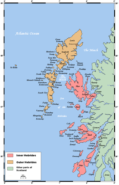
ਤਸਵੀਰ:Hebridesmap.png

ਇਸ ਝਾਤ ਦਾ ਅਕਾਰ: 386 × 599 ਪਿਕਸਲ. ਹੋਰ ਰੈਜ਼ੋਲਿਊਸ਼ਨਜ਼: 155 × 240 ਪਿਕਸਲ | 309 × 480 ਪਿਕਸਲ | 935 × 1,450 ਪਿਕਸਲ.
ਅਸਲ ਫ਼ਾਈਲ (935 × 1,450 ਪਿਕਸਲ, ਫ਼ਾਈਲ ਅਕਾਰ: 61 KB, MIME ਕਿਸਮ: image/png)
ਫ਼ਾਈਲ ਦਾ ਅਤੀਤ
ਤਾਰੀਖ/ਸਮੇਂ ’ਤੇ ਕਲਿੱਕ ਕਰੋ ਤਾਂ ਉਸ ਸਮੇਂ ਦੀ ਫਾਈਲ ਪੇਸ਼ ਹੋ ਜਾਵੇਗੀ।
| ਮਿਤੀ/ਸਮਾਂ | ਨਮੂਨਾ | ਨਾਪ | ਵਰਤੋਂਕਾਰ | ਟਿੱਪਣੀ | |
|---|---|---|---|---|---|
| ਮੌਜੂਦਾ | 21:06, 4 ਅਗਸਤ 2007 |  | 935 × 1,450 (61 KB) | Kelisi | Authorship |
| 22:56, 28 ਜਨਵਰੀ 2006 |  | 935 × 1,450 (61 KB) | Mschlindwein | A map of the Inner and Outer Hebrides in Scotland. This map's source is [http://www.aquarius.geomar.de/omc/make_map.html here], with the uploader's modifications, and the [http://gmt.soest.hawaii.edu/ GMT homepage] says that the tools are released under |
ਫ਼ਾਈਲ ਦੀ ਵਰਤੋਂ
ਇਹ ਫਾਈਲ ਹੇਠਾਂ ਦਿੱਤਾ ਸਫ਼ਾ ਵਰਤਦਾ ਹੈ:
ਫ਼ਾਈਲ ਦੀ ਵਿਆਪਕ ਵਰਤੋਂ
ਇਸ ਫ਼ਾਈਲ ਨੂੰ ਹੋਰ ਹੇਠ ਲਿਖੇ ਵਿਕੀ ਵਰਤਦੇ ਹਨ:
- af.wikipedia.org ਉੱਤੇ ਵਰਤੋਂ
- an.wikipedia.org ਉੱਤੇ ਵਰਤੋਂ
- ar.wikipedia.org ਉੱਤੇ ਵਰਤੋਂ
- ast.wikipedia.org ਉੱਤੇ ਵਰਤੋਂ
- az.wikipedia.org ਉੱਤੇ ਵਰਤੋਂ
- bat-smg.wikipedia.org ਉੱਤੇ ਵਰਤੋਂ
- be.wikipedia.org ਉੱਤੇ ਵਰਤੋਂ
- bg.wikipedia.org ਉੱਤੇ ਵਰਤੋਂ
- bn.wikipedia.org ਉੱਤੇ ਵਰਤੋਂ
- br.wikipedia.org ਉੱਤੇ ਵਰਤੋਂ
- Ìle
- Inizi Gall
- Diùra
- Leòdhas
- Ulbha
- Beàrnaraigh Mòr
- Patrom:Inizi Gall
- Enez Cara
- Gioghaigh
- Rocabarraigh
- Inizi Barraigh
- Barraigh
- Bhatarsaigh
- Uibhist a Deas
- Hiort
- Uibhist a Tuath
- Ì Chaluim Chille
- Enez Sgitheanach
- Muile
- Na h-Eileanan Mora
- Na Hearadh
- Leòdhas agus na Hearadh
- Sgalpaigh na Hearadh
- Na h-Eileanan Ascrib
- Heisgeir
- Canaigh
- Càrna
- Rònaigh an Daimh
- Rònaigh (Sgitheanach)
- Cola
- Colbhasa
- The Minch
- Giogha
- Eige
- Orasaigh (Ìle)
- Orasaigh (Loch Bracadail)
- Rùm
ਇਸ ਫ਼ਾਈਲ ਦੀ ਹੋਰ ਵਿਆਪਕ ਵਰਤੋਂ ਵੇਖੋ।

