ਤਸਵੀਰ:Himalaya annotated.jpg

ਇਸ ਝਾਤ ਦਾ ਅਕਾਰ: 800 × 530 ਪਿਕਸਲ. ਹੋਰ ਰੈਜ਼ੋਲਿਊਸ਼ਨਜ਼: 320 × 212 ਪਿਕਸਲ | 640 × 424 ਪਿਕਸਲ | 1,000 × 662 ਪਿਕਸਲ.
ਅਸਲ ਫ਼ਾਈਲ (1,000 × 662 ਪਿਕਸਲ, ਫ਼ਾਈਲ ਅਕਾਰ: 413 KB, MIME ਕਿਸਮ: image/jpeg)
| ਵੇਰਵਾ |
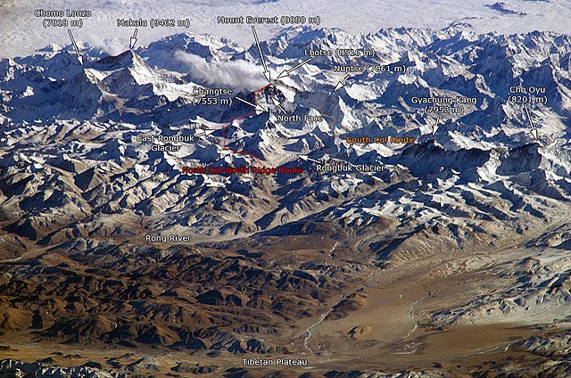
English: The Himalayan mountain range with Mount Everest as seen from the International Space Station looking south-south-east over the Tibetan Plateau. Four of the world's fourteen eight-thousanders, mountains higher than 8000 metres, can be seen, Makalu (8462 m), Everest (8850 m), Lhotse (8516 m) and Cho Oyu (8201 m). The South Col Route is Mount Everest's most often used climbing route. |
|||||
| ਸਰੋਤ |
This image is a modified version of this NASA Image. Annotations have been added by Janderk Jan Derk. If anyone finds errors please leave a note in the discussions area of this page. Original image: NASA |
|||||
| ਲਿਖਾਰੀ | NASA, Janderk Jan Derk | |||||
| ਇਜਾਜ਼ਤ (ਇਸ ਫ਼ਾਈਲ ਦੀ ਮੁੜਵਰਤੋਂ ਕਰੋ) |
|
|||||
| Other versions |
This file was derived from: Himalayas.jpg |

ਫ਼ਾਈਲ ਦਾ ਅਤੀਤ
ਤਾਰੀਖ/ਸਮੇਂ ’ਤੇ ਕਲਿੱਕ ਕਰੋ ਤਾਂ ਉਸ ਸਮੇਂ ਦੀ ਫਾਈਲ ਪੇਸ਼ ਹੋ ਜਾਵੇਗੀ।
| ਮਿਤੀ/ਸਮਾਂ | ਨਮੂਨਾ | ਨਾਪ | ਵਰਤੋਂਕਾਰ | ਟਿੱਪਣੀ | |
|---|---|---|---|---|---|
| ਮੌਜੂਦਾ | 22:39, 6 ਦਸੰਬਰ 2006 | | 1,000 × 662 (413 KB) | Janderk~commonswiki | Slight change in Nuptse location to try to make it point more to Nuptse I. |
| 12:08, 5 ਦਸੰਬਰ 2006 |  | 1,000 × 662 (414 KB) | Janderk~commonswiki | Fixed errors. See talk page. | |
| 18:23, 19 ਫ਼ਰਵਰੀ 2005 |  | 1,000 × 662 (416 KB) | RedWolf | Himalaya - annotated |
ਫ਼ਾਈਲ ਦੀ ਵਰਤੋਂ
ਇਹ ਫਾਈਲ ਹੇਠਾਂ ਦਿੱਤਾ ਸਫ਼ਾ ਵਰਤਦਾ ਹੈ:
ਫ਼ਾਈਲ ਦੀ ਵਿਆਪਕ ਵਰਤੋਂ
ਇਸ ਫ਼ਾਈਲ ਨੂੰ ਹੋਰ ਹੇਠ ਲਿਖੇ ਵਿਕੀ ਵਰਤਦੇ ਹਨ:
- af.wikipedia.org ਉੱਤੇ ਵਰਤੋਂ
- anp.wikipedia.org ਉੱਤੇ ਵਰਤੋਂ
- ast.wikipedia.org ਉੱਤੇ ਵਰਤੋਂ
- awa.wikipedia.org ਉੱਤੇ ਵਰਤੋਂ
- azb.wikipedia.org ਉੱਤੇ ਵਰਤੋਂ
- az.wikipedia.org ਉੱਤੇ ਵਰਤੋਂ
- ba.wikipedia.org ਉੱਤੇ ਵਰਤੋਂ
- bcl.wikipedia.org ਉੱਤੇ ਵਰਤੋਂ
- beta.wikiversity.org ਉੱਤੇ ਵਰਤੋਂ
- be.wikipedia.org ਉੱਤੇ ਵਰਤੋਂ
- bg.wikipedia.org ਉੱਤੇ ਵਰਤੋਂ
- blk.wikipedia.org ਉੱਤੇ ਵਰਤੋਂ
- bn.wikipedia.org ਉੱਤੇ ਵਰਤੋਂ
- bs.wikipedia.org ਉੱਤੇ ਵਰਤੋਂ
- ca.wikipedia.org ਉੱਤੇ ਵਰਤੋਂ
- ckb.wikipedia.org ਉੱਤੇ ਵਰਤੋਂ
- csb.wikipedia.org ਉੱਤੇ ਵਰਤੋਂ
- cs.wikipedia.org ਉੱਤੇ ਵਰਤੋਂ
- da.wikipedia.org ਉੱਤੇ ਵਰਤੋਂ
- de.wikipedia.org ਉੱਤੇ ਵਰਤੋਂ
- el.wikipedia.org ਉੱਤੇ ਵਰਤੋਂ
- en.wikipedia.org ਉੱਤੇ ਵਰਤੋਂ
- eo.wikipedia.org ਉੱਤੇ ਵਰਤੋਂ
ਇਸ ਫ਼ਾਈਲ ਦੀ ਹੋਰ ਵਿਆਪਕ ਵਰਤੋਂ ਵੇਖੋ।