ਤਸਵੀਰ:Volga.A2002137.0745.250m.jpg

ਇਸ ਝਾਤ ਦਾ ਅਕਾਰ: 460 × 600 ਪਿਕਸਲ. ਹੋਰ ਰੈਜ਼ੋਲਿਊਸ਼ਨਜ਼: 184 × 240 ਪਿਕਸਲ | 368 × 480 ਪਿਕਸਲ | 589 × 768 ਪਿਕਸਲ | 785 × 1,024 ਪਿਕਸਲ | 1,570 × 2,048 ਪਿਕਸਲ | 4,600 × 6,000 ਪਿਕਸਲ.
ਅਸਲ ਫ਼ਾਈਲ (4,600 × 6,000 ਪਿਕਸਲ, ਫ਼ਾਈਲ ਅਕਾਰ: 3.91 MB, MIME ਕਿਸਮ: image/jpeg)
http://visibleearth.nasa.gov/view_rec.php?id=3823
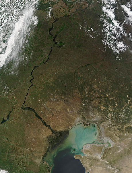
Credit: Jacques Descloitres, MODIS Land Rapid Response Team, NASA/GSFC
This MODIS image from May 17, 2002, shows the Volga River running north-south and emptying into the Caspian Sea. At lower left, extensive cultivation of the land can be seen in the regular patterns of fields. The light-colored waters of the Caspian Sea may be due to high sediment in the rivers that flow into it, as well as pollution and aquatic plant growth.
Metadata
- Sensor: Terra/MODIS
- Datastart: 2002-05-17
- Dataend: 2002-05-17
- Visible Earth v1 ID 19787
- Visualization Date: 2002-05-24
1. All Sensors 2. » MODIS
| This file is in the public domain in the United States because it was solely created by NASA. NASA copyright policy states that "NASA material is not protected by copyright unless noted". (See Template:PD-USGov, NASA copyright policy page or JPL Image Use Policy.) | ||
 |
Warnings:
|
ਫ਼ਾਈਲ ਦਾ ਅਤੀਤ
ਤਾਰੀਖ/ਸਮੇਂ ’ਤੇ ਕਲਿੱਕ ਕਰੋ ਤਾਂ ਉਸ ਸਮੇਂ ਦੀ ਫਾਈਲ ਪੇਸ਼ ਹੋ ਜਾਵੇਗੀ।
| ਮਿਤੀ/ਸਮਾਂ | ਨਮੂਨਾ | ਨਾਪ | ਵਰਤੋਂਕਾਰ | ਟਿੱਪਣੀ | |
|---|---|---|---|---|---|
| ਮੌਜੂਦਾ | 21:38, 25 ਅਗਸਤ 2005 | | 4,600 × 6,000 (3.91 MB) | Nanosmile | http://visibleearth.nasa.gov/view_rec.php?id=3823 Credit: Jacques Descloitres, MODIS Land Rapid Response Team, NASA/GSFC This MODIS image from May 17, 2002, shows the Volga River running north-south and emptying into the Caspian Sea. At lower left, exte |
ਫ਼ਾਈਲ ਦੀ ਵਰਤੋਂ
ਇਹ ਫਾਈਲ ਹੇਠਾਂ ਦਿੱਤਾ ਸਫ਼ਾ ਵਰਤਦਾ ਹੈ:
ਫ਼ਾਈਲ ਦੀ ਵਿਆਪਕ ਵਰਤੋਂ
ਇਸ ਫ਼ਾਈਲ ਨੂੰ ਹੋਰ ਹੇਠ ਲਿਖੇ ਵਿਕੀ ਵਰਤਦੇ ਹਨ:
- ar.wikipedia.org ਉੱਤੇ ਵਰਤੋਂ
- as.wikipedia.org ਉੱਤੇ ਵਰਤੋਂ
- av.wikipedia.org ਉੱਤੇ ਵਰਤੋਂ
- bg.wikipedia.org ਉੱਤੇ ਵਰਤੋਂ
- bh.wikipedia.org ਉੱਤੇ ਵਰਤੋਂ
- bn.wikipedia.org ਉੱਤੇ ਵਰਤੋਂ
- ca.wikipedia.org ਉੱਤੇ ਵਰਤੋਂ
- cv.wikipedia.org ਉੱਤੇ ਵਰਤੋਂ
- cy.wikipedia.org ਉੱਤੇ ਵਰਤੋਂ
- el.wikipedia.org ਉੱਤੇ ਵਰਤੋਂ
- en.wikipedia.org ਉੱਤੇ ਵਰਤੋਂ
- es.wikipedia.org ਉੱਤੇ ਵਰਤੋਂ
- gl.wikipedia.org ਉੱਤੇ ਵਰਤੋਂ
- it.wikipedia.org ਉੱਤੇ ਵਰਤੋਂ
- lad.wikipedia.org ਉੱਤੇ ਵਰਤੋਂ
- no.wikipedia.org ਉੱਤੇ ਵਰਤੋਂ
- pnb.wikipedia.org ਉੱਤੇ ਵਰਤੋਂ
- ro.wikipedia.org ਉੱਤੇ ਵਰਤੋਂ
- sl.wikipedia.org ਉੱਤੇ ਵਰਤੋਂ
- tl.wikipedia.org ਉੱਤੇ ਵਰਤੋਂ
- tr.wikipedia.org ਉੱਤੇ ਵਰਤੋਂ
- uk.wikipedia.org ਉੱਤੇ ਵਰਤੋਂ
- ur.wikipedia.org ਉੱਤੇ ਵਰਤੋਂ