ਤਸਵੀਰ:WorldEmpires.png
ਇਸ ਝਾਤ ਦਾ ਅਕਾਰ: 800 × 480 ਪਿਕਸਲ. ਹੋਰ ਰੈਜ਼ੋਲਿਊਸ਼ਨਜ਼: 320 × 192 ਪਿਕਸਲ | 1,024 × 614 ਪਿਕਸਲ | 1,280 × 768 ਪਿਕਸਲ | 3,000 × 1,800 ਪਿਕਸਲ.
ਅਸਲ ਫ਼ਾਈਲ (3,000 × 1,800 ਪਿਕਸਲ, ਫ਼ਾਈਲ ਅਕਾਰ: 561 KB, MIME ਕਿਸਮ: image/png)
ਸਾਰ
| ਵੇਰਵਾ |
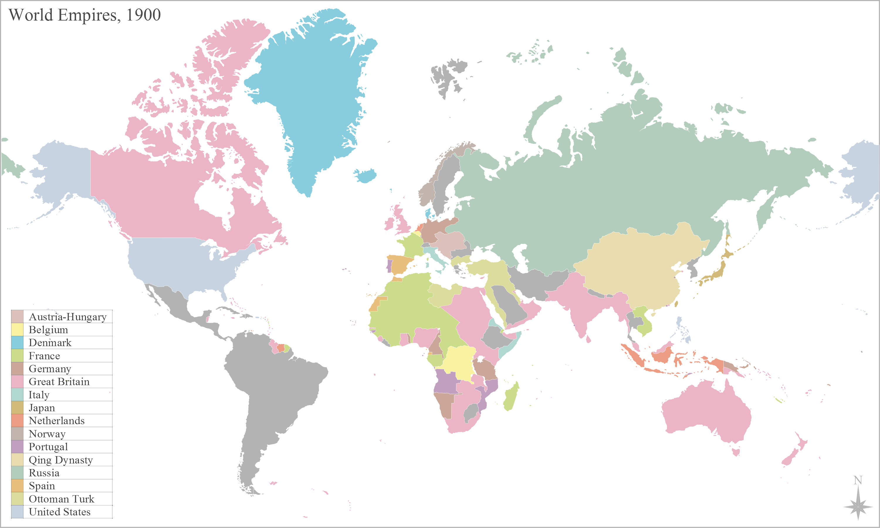
English: Map of the worlds empires, during 1900 |
| ਮਿਤੀ | |
| ਸਰੋਤ | ਆਪਣਾ ਕੰਮ |
| ਲਿਖਾਰੀ | George Bosanko |
ਲਸੰਸ
I, the copyright holder of this work, hereby publish it under the following license:
ਇਸ ਫ਼ਾਈਲ ਦਾ ਲਸੰਸ ਕ੍ਰਿਏਟਿਵ ਕਾਮਨਜ਼ ਐਟ੍ਰੀਬਿਊਸ਼ਨ-ਸ਼ੇਅਰ ਅਲਾਈਕ 3.0 ਅਨਪੋਰਟੇਡ ਹੈ।
- ਤੁਹਾਨੂੰ ਖੁੱਲ੍ਹ ਹੈ:
- ਸਾਂਝਾ ਕਰਨ ਦੀ – ਰਚਨਾ ਨੂੰ ਕਾਪੀ, ਵੰਡਣਾ ਅਤੇ ਭੇਜਣਾ
- ਮੁੜ-ਰਲ਼ਾਉਣ ਦੀ – ਰਚਨਾ ਨੂੰ ਢਾਲਣਾ
- ਥੱਲੇ ਲਿਖੀਆਂ ਸ਼ਰਤਾਂ ਹੇਠ:
- ਗੁਣਾਂ ਦੀ ਦੱਸ – ਉਚਿਤ ਕ੍ਰੈਡਿਟ ਦੇਵੋ, ਲਾਇਸੰਸ ਦਾ ਇੱਕ ਲਿੰਕ ਪ੍ਰਦਾਨ ਕਰੋ ਅਤੇ ਇਹ ਦਰਸਾਓ ਕਿ ਕੀ ਤਬਦੀਲੀਆਂ ਕੀਤੀਆਂ ਗਈਆਂ ਸਨ। ਤੁਸੀਂ ਇਹ ਕਿਸੇ ਵੀ ਵਾਜਬ ਤਰੀਕੇ ਨਾਲ ਕਰ ਸਕਦੇ ਹੋ, ਪਰ ਇਹ ਤਰੀਕਾ ਅਜਿਹਾ ਨਹੀਂ ਹੋਣਾ ਚਾਹੀਦਾ ਜੋ ਇਹ ਦਰਸਾਵੇ ਕਿ ਲਾਇਸੰਸਕਰਤਾ ਤੁਹਾਨੂੰ ਜਾਂ ਤੁਹਾਡੀ ਵਰਤੋਂ ਦਾ ਸਮਰਥਨ ਕਰਦਾ ਹੈ।
- ਸ਼ੇਅਰ ਅਲਾਈਕ – ਜੇਕਰ ਤੁਸੀਂ ਸਮੱਗਰੀ ਨੂੰ ਰੀਮਿਕਸ ਕਰਦੇ ਹੋ, ਬਦਲਦੇ ਹੋ ਜਾਂ ਬਣਾਉਂਦੇ ਹੋ, ਤਾਂ ਆਪਣੇ ਯੋਗਦਾਨ ਇੱਕੋ ਜਿਹੇ ਜਾਂ ਅਨੁਕੂਲ ਲਾਇਸੰਸ ਦੇ ਅਧੀਨ ਕਰੋ।
ਫ਼ਾਈਲ ਦਾ ਅਤੀਤ
ਤਾਰੀਖ/ਸਮੇਂ ’ਤੇ ਕਲਿੱਕ ਕਰੋ ਤਾਂ ਉਸ ਸਮੇਂ ਦੀ ਫਾਈਲ ਪੇਸ਼ ਹੋ ਜਾਵੇਗੀ।
| ਮਿਤੀ/ਸਮਾਂ | ਨਮੂਨਾ | ਨਾਪ | ਵਰਤੋਂਕਾਰ | ਟਿੱਪਣੀ | |
|---|---|---|---|---|---|
| ਮੌਜੂਦਾ | 12:21, 29 ਜਨਵਰੀ 2014 | | 3,000 × 1,800 (561 KB) | Alphathon | Reverted to version as of 16:17, 2 June 2012. Numerous errors introduced (e.g. Nicaragua part of US, Ottoman Empire renamed Turkey) and some changes which don't apply accross whole (newly intorduced) time span (e.g. Italian Libya, non-Ottoman Balkans) |
| 02:25, 18 ਅਗਸਤ 2013 |  | 3,000 × 1,800 (674 KB) | Mttll | Fixed legend | |
| 16:17, 2 ਜੂਨ 2012 |  | 3,000 × 1,800 (561 KB) | GBozanko | Change date and fixes to coincide with that; Added Qing Dynasty; removal of Transvaal and Orange Free State from British South Africa; addition of Ottoman European Territories; removal of US administration of Nicaragua; fix of British Nigeria and Germa... | |
| 15:24, 26 ਮਈ 2012 |  | 3,000 × 1,800 (559 KB) | Geord0 | Harmonious with 'British Somaliland 1884–1960' article, and sourced map from the United Kingdom National Archive 'maps in time' http://www.nationalarchives.gov.uk/cabinetpapers/themes/maps-interactive/maps-in-time.htm | |
| 14:35, 26 ਮਈ 2012 |  | 801 × 480 (111 KB) | Runehelmet | British Somaliland and North Western part of Italian Somaliland were under control of the Dervish State in the given timeline. | |
| 15:30, 19 ਮਈ 2012 |  | 3,000 × 1,800 (559 KB) | Geord0 |
ਫ਼ਾਈਲ ਦੀ ਵਰਤੋਂ
ਇਹ ਫਾਈਲ ਹੇਠਾਂ ਦਿੱਤਾ ਸਫ਼ਾ ਵਰਤਦਾ ਹੈ:
ਫ਼ਾਈਲ ਦੀ ਵਿਆਪਕ ਵਰਤੋਂ
ਇਸ ਫ਼ਾਈਲ ਨੂੰ ਹੋਰ ਹੇਠ ਲਿਖੇ ਵਿਕੀ ਵਰਤਦੇ ਹਨ:
- af.wikipedia.org ਉੱਤੇ ਵਰਤੋਂ
- ar.wikipedia.org ਉੱਤੇ ਵਰਤੋਂ
- إمبراطورية
- بوابة:الإمبراطورية الروسية
- بوابة:الإمبراطورية الروسية/بوابات شقيقة
- بوابة:الإمبراطورية الألمانية
- بوابة:الإمبراطورية الألمانية/بوابات شقيقة
- بوابة:إمبراطورية اليابان
- بوابة:إمبراطورية اليابان/بوابات شقيقة
- بوابة:الخلافة الراشدة
- بوابة:الدولة الأموية
- بوابة:الإمبراطورية الفرنسية الأولى/بوابات شقيقة
- بوابة:الإمبراطورية الفرنسية الأولى
- بوابة:الإمبراطورية النمساوية/بوابات شقيقة
- بوابة:الإمبراطورية النمساوية
- بوابة:الإمبراطورية البريطانية
- بوابة:الإمبراطورية البريطانية/بوابات شقيقة
- بوابة:الإمبراطورية الفرنسية الثانية
- بوابة:الإمبراطورية الفرنسية الثانية/بوابات شقيقة
- بوابة:الإمبراطورية البرتغالية
- بوابة:الإمبراطورية البرتغالية/بوابات شقيقة
- بوابة:الإمبراطورية النمساوية المجرية
- بوابة:الإمبراطورية النمساوية المجرية/بوابات شقيقة
- بوابة:الإمبراطورية المغولية
- بوابة:الإمبراطورية المغولية/بوابات شقيقة
- بوابة:الإمبراطورية الإسبانية
- بوابة:إمبراطوريات
- بوابة:إمبراطوريات/واجهة
- بوابة:إمبراطوريات/بوابات شقيقة
- بوابة:الإمبراطورية الإسبانية/بوابات شقيقة
- بوابة:الدولة الأموية/بوابات شقيقة
- بوابة:الخلافة الراشدة/بوابات شقيقة
- بوابة:مملكة فرنسا
- بوابة:مملكة فرنسا/بوابات شقيقة
- بوابة:الإمبراطورية الرومانية المقدسة
- بوابة:الإمبراطورية الرومانية المقدسة/بوابات شقيقة
- قالب:بوابات الإمبراطوريات
- azb.wikipedia.org ਉੱਤੇ ਵਰਤੋਂ
- ca.wikipedia.org ਉੱਤੇ ਵਰਤੋਂ
- en.wikipedia.org ਉੱਤੇ ਵਰਤੋਂ
- es.wikipedia.org ਉੱਤੇ ਵਰਤੋਂ
- gom.wikipedia.org ਉੱਤੇ ਵਰਤੋਂ
- hy.wikipedia.org ਉੱਤੇ ਵਰਤੋਂ
ਇਸ ਫ਼ਾਈਲ ਦੀ ਹੋਰ ਵਿਆਪਕ ਵਰਤੋਂ ਵੇਖੋ।