ਤਸਵੀਰ:Yangtze River Map.png
ਇਸ ਤੋਂ ਵੱਡੀ ਤਸਵੀਰ ਮੌਜੂਦ ਨਹੀਂ ਹੈ।
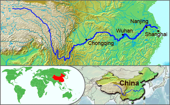
Yangtze_River_Map.png (576 × 355 ਪਿਕਸਲ, ਫ਼ਾਈਲ ਅਕਾਰ: 123 KB, MIME ਕਿਸਮ: image/png)
ਸਾਰ
| ਵੇਰਵਾ |
English: The underlying topographic maps used in this image come from the Demis Web Map Server, and are in the public domain. The world locator map is derived from :Image:BlankMap-World.png. I added the feature layers myself. —Papayoung ☯ 20:57, 1 October 2005 (UTC) |
| ਮਿਤੀ | 1 ਅਕਤੂਬਰ 2005 (original upload date) |
| ਸਰੋਤ | Transferred from en.wikipedia to Commons by Common Good using CommonsHelper. |
| ਲਿਖਾਰੀ | The original uploader was Papayoung at ਅੰਗਰੇਜ਼ੀ ਵਿਕੀਪੀਡੀਆ. |
| Other versions |
|
.JPG)
ਲਸੰਸ
| ਇਸ ਫ਼ਾਈਲ ਦਾ ਲਸੰਸ ਕ੍ਰਿਏਟਿਵ ਕਾਮਨਜ਼ ਐਟ੍ਰੀਬਿਊਸ਼ਨ-ਸ਼ੇਅਰ ਅਲਾਈਕ 3.0 ਅਨਪੋਰਟੇਡ ਹੈ। Subject to disclaimers. | ||
| ||
| This licensing tag was added to this file as part of the GFDL licensing update. |

|
ਇਸ ਸਫ਼ੇ ਨੂੰ ਗਨੂ ਲਸੰਸ, ਵਰਜ਼ਨ 1.2 ਜਾਂ ਫਰੀ ਸਾਫਟਵੇਅਰ ਫਾਊਂਡੇਸ਼ਨ ਦੁਆਰਾ ਪ੍ਰਕਾਸ਼ਿਤ ਕੀਤੇ ਨਵੇਂ ਵਰਜ਼ਨ ਤਹਿਤ ਕਾਪੀ ਕਰਨ, ਵੰਡਣ ਜਾਂ/ਅਤੇ ਤਬਦੀਲੀ ਕਰਨ ਦੀ ਖੁੱਲ ਹੈ; ਬਿਨਾ ਕਿਸੇ ਸਥਿਰ ਫਰੰਟ-ਕਵਰ ਜਾਂ ਬੈਕ ਕਵਰ ਲਿਖਤਾਂ ਤੋਂ ਬਿਨਾਂ। ਇਸ ਲਸੰਸ ਦੀ ਇੱਕ ਕਾਪੀ ਇਸ ਗਨੂ ਫਰੀ ਲਸੰਸ ਭਾਗ ਵਿੱਚ ਮੌਜੂਦ ਹੈ। Subject to disclaimers. |
Original upload log
The original description page was here. All following user names refer to en.wikipedia.
- 2005-10-01 20:51 Papayoung 576×355× (125604 bytes) The underlying topographic maps used in this image come from the [http://www2.demis.nl/mapserver/mapper.asp Demis Web Map Server], and are in the public domain. The world locator map is derived from [[Commons:Image:BlankMap-World.png|BlankMap-World.png]].
- 2005-09-25 22:57 Papayoung 936×363× (221574 bytes) The underlying topographic maps used in this image come from the [http://www2.demis.nl/mapserver/mapper.asp Demis Web Map Server], and are in the public domain. I added the feature layers myself. —~~~~
ਫ਼ਾਈਲ ਦਾ ਅਤੀਤ
ਤਾਰੀਖ/ਸਮੇਂ ’ਤੇ ਕਲਿੱਕ ਕਰੋ ਤਾਂ ਉਸ ਸਮੇਂ ਦੀ ਫਾਈਲ ਪੇਸ਼ ਹੋ ਜਾਵੇਗੀ।
| ਮਿਤੀ/ਸਮਾਂ | ਨਮੂਨਾ | ਨਾਪ | ਵਰਤੋਂਕਾਰ | ਟਿੱਪਣੀ | |
|---|---|---|---|---|---|
| ਮੌਜੂਦਾ | 20:30, 7 ਮਈ 2009 | | 576 × 355 (123 KB) | File Upload Bot (Magnus Manske) | {{BotMoveToCommons|en.wikipedia|year={{subst:CURRENTYEAR}}|month={{subst:CURRENTMONTHNAME}}|day={{subst:CURRENTDAY}}}} {{Information |Description={{en|The underlying topographic maps used in this image come from the [http://www2.demis.nl/mapserver/mapper |
ਫ਼ਾਈਲ ਦੀ ਵਰਤੋਂ
ਇਹ ਫਾਈਲ ਹੇਠਾਂ ਦਿੱਤੇ 2 ਸਫ਼ੇ ਵਰਤਦੇ ਹਨ:
ਫ਼ਾਈਲ ਦੀ ਵਿਆਪਕ ਵਰਤੋਂ
ਇਸ ਫ਼ਾਈਲ ਨੂੰ ਹੋਰ ਹੇਠ ਲਿਖੇ ਵਿਕੀ ਵਰਤਦੇ ਹਨ:
- af.wikipedia.org ਉੱਤੇ ਵਰਤੋਂ
- als.wikipedia.org ਉੱਤੇ ਵਰਤੋਂ
- am.wikipedia.org ਉੱਤੇ ਵਰਤੋਂ
- ary.wikipedia.org ਉੱਤੇ ਵਰਤੋਂ
- ast.wikipedia.org ਉੱਤੇ ਵਰਤੋਂ
- as.wikipedia.org ਉੱਤੇ ਵਰਤੋਂ
- azb.wikipedia.org ਉੱਤੇ ਵਰਤੋਂ
- be-tarask.wikipedia.org ਉੱਤੇ ਵਰਤੋਂ
- bh.wikipedia.org ਉੱਤੇ ਵਰਤੋਂ
- bn.wikipedia.org ਉੱਤੇ ਵਰਤੋਂ
- bo.wikipedia.org ਉੱਤੇ ਵਰਤੋਂ
- br.wikipedia.org ਉੱਤੇ ਵਰਤੋਂ
- cs.wikipedia.org ਉੱਤੇ ਵਰਤੋਂ
- de.wikipedia.org ਉੱਤੇ ਵਰਤੋਂ
- en.wikipedia.org ਉੱਤੇ ਵਰਤੋਂ
- en.wikinews.org ਉੱਤੇ ਵਰਤੋਂ
- es.wikipedia.org ਉੱਤੇ ਵਰਤੋਂ
- et.wikipedia.org ਉੱਤੇ ਵਰਤੋਂ
- eu.wikipedia.org ਉੱਤੇ ਵਰਤੋਂ
- fi.wikipedia.org ਉੱਤੇ ਵਰਤੋਂ
- fo.wikipedia.org ਉੱਤੇ ਵਰਤੋਂ
- frr.wikipedia.org ਉੱਤੇ ਵਰਤੋਂ
- fr.wikipedia.org ਉੱਤੇ ਵਰਤੋਂ
- fr.wikivoyage.org ਉੱਤੇ ਵਰਤੋਂ
- fr.wiktionary.org ਉੱਤੇ ਵਰਤੋਂ
- fy.wikipedia.org ਉੱਤੇ ਵਰਤੋਂ
- hi.wikipedia.org ਉੱਤੇ ਵਰਤੋਂ
- hu.wikipedia.org ਉੱਤੇ ਵਰਤੋਂ
- hy.wikipedia.org ਉੱਤੇ ਵਰਤੋਂ
- hyw.wikipedia.org ਉੱਤੇ ਵਰਤੋਂ
- id.wikipedia.org ਉੱਤੇ ਵਰਤੋਂ
- ilo.wikipedia.org ਉੱਤੇ ਵਰਤੋਂ
- incubator.wikimedia.org ਉੱਤੇ ਵਰਤੋਂ
- io.wikipedia.org ਉੱਤੇ ਵਰਤੋਂ
- it.wikipedia.org ਉੱਤੇ ਵਰਤੋਂ
- ja.wikipedia.org ਉੱਤੇ ਵਰਤੋਂ
- ka.wikipedia.org ਉੱਤੇ ਵਰਤੋਂ
- ko.wikipedia.org ਉੱਤੇ ਵਰਤੋਂ
- ku.wikipedia.org ਉੱਤੇ ਵਰਤੋਂ
- la.wikipedia.org ਉੱਤੇ ਵਰਤੋਂ
- lfn.wikipedia.org ਉੱਤੇ ਵਰਤੋਂ
ਇਸ ਫ਼ਾਈਲ ਦੀ ਹੋਰ ਵਿਆਪਕ ਵਰਤੋਂ ਵੇਖੋ।