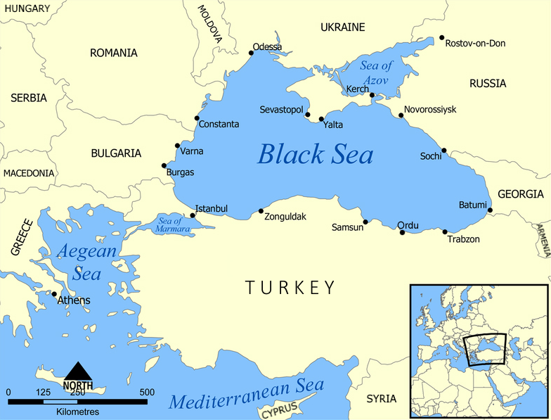
ਤਸਵੀਰ:Black Sea map.png
Black_Sea_map.png (784 × 597 ਪਿਕਸਲ, ਫ਼ਾਈਲ ਅਕਾਰ: 337 KB, MIME ਕਿਸਮ: image/png)
ਫ਼ਾਈਲ ਦਾ ਅਤੀਤ
ਤਾਰੀਖ/ਸਮੇਂ ’ਤੇ ਕਲਿੱਕ ਕਰੋ ਤਾਂ ਉਸ ਸਮੇਂ ਦੀ ਫਾਈਲ ਪੇਸ਼ ਹੋ ਜਾਵੇਗੀ।
| ਮਿਤੀ/ਸਮਾਂ | ਨਮੂਨਾ | ਨਾਪ | ਵਰਤੋਂਕਾਰ | ਟਿੱਪਣੀ | |
|---|---|---|---|---|---|
| ਮੌਜੂਦਾ | 12:00, 19 ਅਪਰੈਲ 2022 |  | 784 × 597 (337 KB) | Sebastian Wallroth | Cropped < 1 % horizontally, < 1 % vertically using CropTool with lossless mode. Removed border. |
| 22:08, 22 ਫ਼ਰਵਰੀ 2022 |  | 786 × 599 (369 KB) | Weaveravel | A few additional labels | |
| 22:56, 28 ਫ਼ਰਵਰੀ 2020 |  | 786 × 599 (335 KB) | 4nn1l2 | Reverted to version as of 18:02, 6 December 2015 (UTC) Please upload as a new file | |
| 22:08, 28 ਫ਼ਰਵਰੀ 2020 |  | 1,074 × 818 (742 KB) | ماني | Black Sea map. Persian version. | |
| 18:02, 6 ਦਸੰਬਰ 2015 |  | 786 × 599 (335 KB) | Ahmet Gürsakal | Updated maps to add Turkish city of Ordu. | |
| 18:10, 10 ਜੁਲਾਈ 2007 |  | 1,200 × 915 (374 KB) | NormanEinstein | Updated maps to add Russian city of Sochi. | |
| 19:11, 7 ਮਈ 2007 |  | 1,200 × 912 (370 KB) | NormanEinstein | Corrected city name typo. | |
| 13:10, 29 ਮਈ 2006 |  | 1,200 × 914 (133 KB) | NormanEinstein | Reduced image size. | |
| 14:54, 25 ਜੁਲਾਈ 2005 |  | 1,200 × 916 (476 KB) | NormanEinstein | A map showing the location of the Black Sea and some of the large or prominent ports around it. The Sea of Azov and Sea of Maramara are also labelled. Created by NormanEinstein, July 25, 2005. {{GFDL-self}} Category:Maps of seas |
ਫ਼ਾਈਲ ਦੀ ਵਰਤੋਂ
ਇਹ ਫਾਈਲ ਹੇਠਾਂ ਦਿੱਤੇ 2 ਸਫ਼ੇ ਵਰਤਦੇ ਹਨ:
ਫ਼ਾਈਲ ਦੀ ਵਿਆਪਕ ਵਰਤੋਂ
ਇਸ ਫ਼ਾਈਲ ਨੂੰ ਹੋਰ ਹੇਠ ਲਿਖੇ ਵਿਕੀ ਵਰਤਦੇ ਹਨ:
- am.wikipedia.org ਉੱਤੇ ਵਰਤੋਂ
- ar.wikipedia.org ਉੱਤੇ ਵਰਤੋਂ
- as.wikipedia.org ਉੱਤੇ ਵਰਤੋਂ
- az.wikipedia.org ਉੱਤੇ ਵਰਤੋਂ
- az.wiktionary.org ਉੱਤੇ ਵਰਤੋਂ
- ban.wikipedia.org ਉੱਤੇ ਵਰਤੋਂ
- ba.wikipedia.org ਉੱਤੇ ਵਰਤੋਂ
- be-tarask.wikipedia.org ਉੱਤੇ ਵਰਤੋਂ
- be.wikipedia.org ਉੱਤੇ ਵਰਤੋਂ
- bg.wikipedia.org ਉੱਤੇ ਵਰਤੋਂ
- bh.wikipedia.org ਉੱਤੇ ਵਰਤੋਂ
- bn.wikipedia.org ਉੱਤੇ ਵਰਤੋਂ
- bs.wikipedia.org ਉੱਤੇ ਵਰਤੋਂ
- bxr.wikipedia.org ਉੱਤੇ ਵਰਤੋਂ
- co.wikipedia.org ਉੱਤੇ ਵਰਤੋਂ
- cs.wikipedia.org ਉੱਤੇ ਵਰਤੋਂ
- cy.wikipedia.org ਉੱਤੇ ਵਰਤੋਂ
- da.wikipedia.org ਉੱਤੇ ਵਰਤੋਂ
- de.wikipedia.org ਉੱਤੇ ਵਰਤੋਂ
- el.wikipedia.org ਉੱਤੇ ਵਰਤੋਂ
- en.wikipedia.org ਉੱਤੇ ਵਰਤੋਂ
- Black Sea
- Sea of Azov
- Black Sea Fleet
- Odesa–Brody pipeline
- Category:Black Sea
- Blue Stream
- User:NormanEinstein/gallery
- Lukoil Neftohim Burgas
- Burgas–Alexandroupoli pipeline
- Caspian Pipeline Consortium
- Samsun–Ceyhan pipeline
- AMBO pipeline
- Pan-European Oil Pipeline
- White Stream
- South Stream
- Grozny–Tuapse oil pipeline
- Baku–Supsa Pipeline
- Baku–Novorossiysk pipeline
- Baku–Batumi pipeline
- Ocean fisheries
- Kulevi oil terminal
- German–Soviet Axis talks
- Petromidia Refinery
- Internationalization of the Danube River
- Azerbaijan–Georgia–Romania Interconnector
- Delta VI oil field
ਇਸ ਫ਼ਾਈਲ ਦੀ ਹੋਰ ਵਿਆਪਕ ਵਰਤੋਂ ਵੇਖੋ।


