ਤਸਵੀਰ:Map Dutch World scris.png
ਇਸ ਝਾਤ ਦਾ ਅਕਾਰ: 800 × 351 ਪਿਕਸਲ. ਹੋਰ ਰੈਜ਼ੋਲਿਊਸ਼ਨਜ਼: 320 × 140 ਪਿਕਸਲ | 640 × 281 ਪਿਕਸਲ | 1,425 × 625 ਪਿਕਸਲ.
ਅਸਲ ਫ਼ਾਈਲ (1,425 × 625 ਪਿਕਸਲ, ਫ਼ਾਈਲ ਅਕਾਰ: 61 KB, MIME ਕਿਸਮ: image/png)
ਸਾਰ
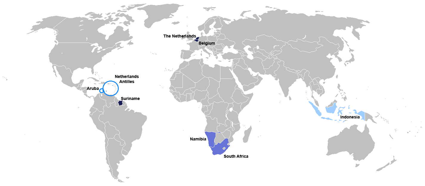
New map for Dutch-speaking world with country names. Modified version of Image:Map Dutch World nou.png
Deutsch: Legende:
- Dunkelblau: Mutter- und Mehrheitssprache
- Blau: Afrikaans (Tochtersprache)
- Hellblau: Zweit- oder nicht offizielle Sprache bzw. weiterhin vorhandene Kenntnis
English: English: Legend:
- Dark blue: native and majority language
- Blue: Afrikaans (daughter language)
- Light blue: secondary (non-official language), where some knowledge persists
Français : Français : Légende:
- Bleu foncé : langue maternelle et majoritaire
- Bleu : Afrikaans («langue fille»)
- Bleu clair : langue secondaire ou non officielle
Italiano: Italiano: Legenda:
- Blu scuro: lingua madre e maggioritaria
- Blu: Afrikaans (lingua affiliata)
- Blu chiaro: seconda lingua e/o non ufficiale, dove la sua conoscenza persiste sino ad oggi
Nederlands: Nederlands: Legenda:
- Donkerblauw: Moedertaal en belangrijkste taal
- Blauw: Afrikaans (dochtertaal)
- Lichtblauw: secundaire taal (niet-officiële taal), waar enkele kennis bestaat
Português: Português: Legenda:
- Azul escuro: língua mãe e majoritária
- Azul: Africâner (língua descendente)
- Azul claro: língua secundária (não oficial), onde ainda persiste algum conhecimento
Română: Română: Legendă:
- Albastru închis: limbă naţională
- Albastru: Afrikaans
- Albastru deschis: limbă secundară, neoficială
Español: Español : Leyenda:
- Azul obscuro : lengua materna y mayoritaria
- Azul : Afrikaans (lengua «hija»)
- Azul claro : lengua secundaria (no oficial), donde aún persiste conocimiento de ella.

|
This file has been superseded by Map of the Dutch World.svg. It is recommended to use the other file. Please note that deleting superseded images requires consent.
|

|
File:Map of the Dutch World.svg is a vector version of this file. It should be used in place of this PNG file.
File:Map Dutch World scris.png → File:Map of the Dutch World.svg
For more information, see Help:SVG. |
 |
ਲਸੰਸ
I, the copyright holder of this work, hereby publish it under the following license:

|
ਇਸ ਸਫ਼ੇ ਨੂੰ ਗਨੂ ਲਸੰਸ, ਵਰਜ਼ਨ 1.2 ਜਾਂ ਫਰੀ ਸਾਫਟਵੇਅਰ ਫਾਊਂਡੇਸ਼ਨ ਦੁਆਰਾ ਪ੍ਰਕਾਸ਼ਿਤ ਕੀਤੇ ਨਵੇਂ ਵਰਜ਼ਨ ਤਹਿਤ ਕਾਪੀ ਕਰਨ, ਵੰਡਣ ਜਾਂ/ਅਤੇ ਤਬਦੀਲੀ ਕਰਨ ਦੀ ਖੁੱਲ ਹੈ; ਬਿਨਾ ਕਿਸੇ ਸਥਿਰ ਫਰੰਟ-ਕਵਰ ਜਾਂ ਬੈਕ ਕਵਰ ਲਿਖਤਾਂ ਤੋਂ ਬਿਨਾਂ। ਇਸ ਲਸੰਸ ਦੀ ਇੱਕ ਕਾਪੀ ਇਸ ਗਨੂ ਫਰੀ ਲਸੰਸ ਭਾਗ ਵਿੱਚ ਮੌਜੂਦ ਹੈ। |
| ਇਸ ਫ਼ਾਈਲ ਦਾ ਲਸੰਸ ਕ੍ਰਿਏਟਿਵ ਕਾਮਨਜ਼ ਐਟ੍ਰੀਬਿਊਸ਼ਨ-ਸ਼ੇਅਰ ਅਲਾਈਕ 3.0 ਅਨਪੋਰਟੇਡ ਹੈ। | ||
| ||
| This licensing tag was added to this file as part of the GFDL licensing update. |
ਫ਼ਾਈਲ ਦਾ ਅਤੀਤ
ਤਾਰੀਖ/ਸਮੇਂ ’ਤੇ ਕਲਿੱਕ ਕਰੋ ਤਾਂ ਉਸ ਸਮੇਂ ਦੀ ਫਾਈਲ ਪੇਸ਼ ਹੋ ਜਾਵੇਗੀ।
| ਮਿਤੀ/ਸਮਾਂ | ਨਮੂਨਾ | ਨਾਪ | ਵਰਤੋਂਕਾਰ | ਟਿੱਪਣੀ | |
|---|---|---|---|---|---|
| ਮੌਜੂਦਾ | 19:06, 7 ਜੁਲਾਈ 2010 | | 1,425 × 625 (61 KB) | Hooiwind | deeper colours so it is easier to see the countries on a smaller scale + removal of "minority dots", geographically confusing and pretty arbitrary. |
| 17:46, 16 ਫ਼ਰਵਰੀ 2007 |  | 1,425 × 625 (34 KB) | Danutz | New map for Dutch-speaking world with country names. Modified version of Image:Map Dutch World nou.png English: Legend: *Dark blue: native language *Blue: administrative language *Light blue: secondary, non-official language *Green square: minori |
ਫ਼ਾਈਲ ਦੀ ਵਰਤੋਂ
ਇਸ ਫ਼ਾਈਲ ਦੀ ਵਰਤੋਂ ਕਰਨ ਵਾਲੇ ਕੋਈ ਪੰਨੇ ਨਹੀਂ ਹਨ।
ਫ਼ਾਈਲ ਦੀ ਵਿਆਪਕ ਵਰਤੋਂ
ਇਸ ਫ਼ਾਈਲ ਨੂੰ ਹੋਰ ਹੇਠ ਲਿਖੇ ਵਿਕੀ ਵਰਤਦੇ ਹਨ:
- jv.wikipedia.org ਉੱਤੇ ਵਰਤੋਂ
- nl.wikibooks.org ਉੱਤੇ ਵਰਤੋਂ
- sat.wikipedia.org ਉੱਤੇ ਵਰਤੋਂ