ਤਸਵੀਰ:PAK AU T1.svg

Size of this PNG preview of this SVG file: 750 × 600 ਪਿਕਸਲ. ਹੋਰ ਰੈਜ਼ੋਲਿਊਸ਼ਨਜ਼: 300 × 240 ਪਿਕਸਲ | 600 × 480 ਪਿਕਸਲ | 960 × 768 ਪਿਕਸਲ | 1,280 × 1,024 ਪਿਕਸਲ | 2,560 × 2,048 ਪਿਕਸਲ | 1,000 × 800 ਪਿਕਸਲ.
ਅਸਲ ਫ਼ਾਈਲ (SVG ਫ਼ਾਈਲ, ਆਮ ਤੌਰ ’ਤੇ 1,000 × 800 ਪਿਕਸਲ, ਫ਼ਾਈਲ ਦਾ ਅਕਾਰ: 19 KB)
ਸਾਰ
| ਵੇਰਵਾ |
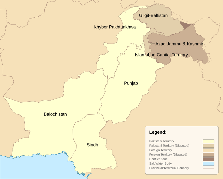
English: Pakistan Administrative Units - Tier 1. This map is based on the Pakistan location map and district maps obtained from respective government websites of Punjab, Sindh, Balochistan and Khyber Pakhtunkhwah. The map has been greatly simplified by reducing the number of data points to reduce file size and modified to include the latest districts as of 2010. |
| ਮਿਤੀ | |
| ਸਰੋਤ | ਆਪਣਾ ਕੰਮ |
| ਲਿਖਾਰੀ | Schajee |
| Other versions |
|


ਲਸੰਸ
| I, the copyright holder of this work, release this work into the public domain. This applies worldwide. In some countries this may not be legally possible; if so: I grant anyone the right to use this work for any purpose, without any conditions, unless such conditions are required by law. |
ਫ਼ਾਈਲ ਦਾ ਅਤੀਤ
ਤਾਰੀਖ/ਸਮੇਂ ’ਤੇ ਕਲਿੱਕ ਕਰੋ ਤਾਂ ਉਸ ਸਮੇਂ ਦੀ ਫਾਈਲ ਪੇਸ਼ ਹੋ ਜਾਵੇਗੀ।
| ਮਿਤੀ/ਸਮਾਂ | ਨਮੂਨਾ | ਨਾਪ | ਵਰਤੋਂਕਾਰ | ਟਿੱਪਣੀ | |
|---|---|---|---|---|---|
| ਮੌਜੂਦਾ | 23:04, 14 ਫ਼ਰਵਰੀ 2021 | | 1,000 × 800 (19 KB) | M Imtiaz | As the previous uploader said, territorial disputes between China and India are irrelevant to this map as long as Pakistan does not claim those territories as part of itself, so I have changed the colour of Shaksgram, Aqsai Chin, etc. accordingly. |
| 08:43, 25 ਅਕਤੂਬਰ 2020 |  | 1,000 × 800 (19 KB) | Swtadi143 | This should only show area in names whoch pakistan claims instead of showing areas disputed by India like shaksgam valley which is a dispute between china and India and not pakistan and India this map is wrong to show the administrative map of pakistan so I am reverting it Reverted to version as of 20:35, 2 June 2018 (UTC) | |
| 18:49, 5 ਸਤੰਬਰ 2019 |  | 1,000 × 800 (22 KB) | SPQR10 | Added Jammu & Kashmir,Siachen Galcier,Shaksgam Valley | |
| 20:35, 2 ਜੂਨ 2018 |  | 1,000 × 800 (19 KB) | ASDFGH | FATA merged into KP | |
| 18:37, 10 ਅਕਤੂਬਰ 2010 |  | 1,000 × 800 (15 KB) | Schajee | Converted polygons to paths; added legend; | |
| 11:54, 8 ਅਕਤੂਬਰ 2010 |  | 1,000 × 800 (18 KB) | Schajee | Adjusted text-alignment and shading for disputed territories | |
| 10:59, 8 ਅਕਤੂਬਰ 2010 |  | 1,000 × 800 (18 KB) | Schajee | Reduced file size by simplifying outlines. Colors are now in accordance with Wikipedia Map Guidelines. | |
| 02:37, 27 ਸਤੰਬਰ 2010 |  | 685 × 500 (113 KB) | Schajee | Fixed Height/Width issue Changed Colors | |
| 02:35, 27 ਸਤੰਬਰ 2010 |  | 685 × 500 (114 KB) | Schajee | Reverted to version as of 18:26, 20 September 2010 | |
| 02:34, 27 ਸਤੰਬਰ 2010 |  | 512 × 512 (113 KB) | Schajee | Added pattern for disputed regions Fixed name for Khyber Pakhtunkhwah |
ਫ਼ਾਈਲ ਦੀ ਵਰਤੋਂ
ਇਹ ਫਾਈਲ ਹੇਠਾਂ ਦਿੱਤਾ ਸਫ਼ਾ ਵਰਤਦਾ ਹੈ:
ਫ਼ਾਈਲ ਦੀ ਵਿਆਪਕ ਵਰਤੋਂ
ਇਸ ਫ਼ਾਈਲ ਨੂੰ ਹੋਰ ਹੇਠ ਲਿਖੇ ਵਿਕੀ ਵਰਤਦੇ ਹਨ:
- be-tarask.wikipedia.org ਉੱਤੇ ਵਰਤੋਂ
- be.wikipedia.org ਉੱਤੇ ਵਰਤੋਂ
- bn.wikipedia.org ਉੱਤੇ ਵਰਤੋਂ
- en.wikipedia.org ਉੱਤੇ ਵਰਤੋਂ
- es.wikipedia.org ਉੱਤੇ ਵਰਤੋਂ
- fr.wikipedia.org ਉੱਤੇ ਵਰਤੋਂ
- id.wikipedia.org ਉੱਤੇ ਵਰਤੋਂ
- is.wikipedia.org ਉੱਤੇ ਵਰਤੋਂ
- kn.wikipedia.org ਉੱਤੇ ਵਰਤੋਂ
- mzn.wikipedia.org ਉੱਤੇ ਵਰਤੋਂ
- pt.wikipedia.org ਉੱਤੇ ਵਰਤੋਂ
- sd.wikipedia.org ਉੱਤੇ ਵਰਤੋਂ
- tg.wikipedia.org ਉੱਤੇ ਵਰਤੋਂ
- ur.wikipedia.org ਉੱਤੇ ਵਰਤੋਂ
- vi.wikipedia.org ਉੱਤੇ ਵਰਤੋਂ