ਤਸਵੀਰ:Scotland map-en.svg

Size of this PNG preview of this SVG file: 417 × 599 ਪਿਕਸਲ. ਹੋਰ ਰੈਜ਼ੋਲਿਊਸ਼ਨਜ਼: 167 × 240 ਪਿਕਸਲ | 334 × 480 ਪਿਕਸਲ | 534 × 768 ਪਿਕਸਲ | 712 × 1,024 ਪਿਕਸਲ | 1,425 × 2,048 ਪਿਕਸਲ | 2,400 × 3,450 ਪਿਕਸਲ.
ਅਸਲ ਫ਼ਾਈਲ (SVG ਫ਼ਾਈਲ, ਆਮ ਤੌਰ ’ਤੇ 2,400 × 3,450 ਪਿਕਸਲ, ਫ਼ਾਈਲ ਦਾ ਅਕਾਰ: 4.35 MB)
ਸਾਰ
| Camera location | | View this and other nearby images on: OpenStreetMap |
|---|
| ਵੇਰਵਾ |
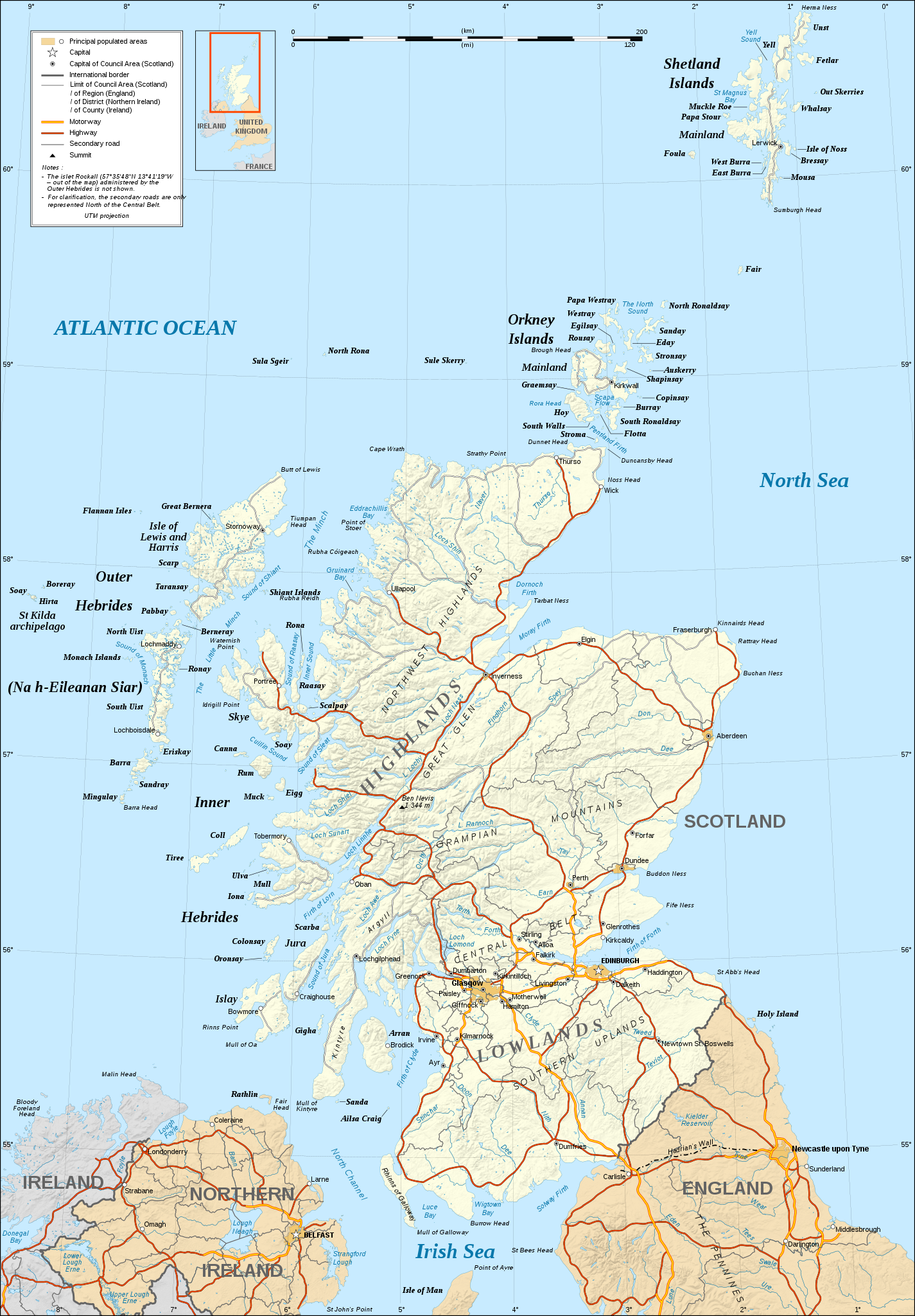
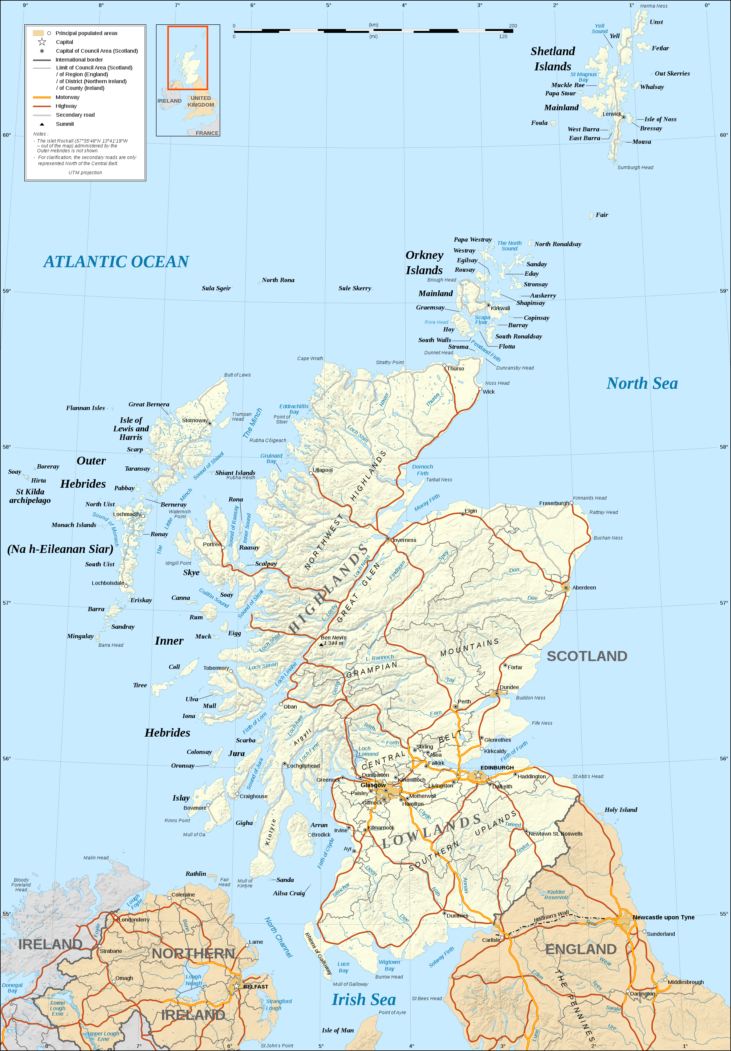
English: Map in English of Scotland.
Note: The shaded relief is a raster image embedded in the SVG file. Français : Carte en anglais de l'Écosse.
Note : Le relief ombré est une image bitmap embarquée dans le fichier SVG. Approximate scales: 1:3,000,000 (accuracy : about 750 m) until 60.38° and 1:4,000,000 (accuracy : about 1,000 m) North of 60.38° |
||
| ਮਿਤੀ | |||
| ਸਰੋਤ |
Own work ;
|
||
| ਲਿਖਾਰੀ | Eric Gaba (Sting - fr:Sting) | ||
| ਇਜਾਜ਼ਤ (ਇਸ ਫ਼ਾਈਲ ਦੀ ਮੁੜਵਰਤੋਂ ਕਰੋ) |
|
||
| Other versions |
Derivative works of this file: ScotlandMoray.svg
[]
|


|
This SVG file contains embedded text that can be translated into your language, using any capable SVG editor, text editor or the SVG Translate tool. For more information see: About translating SVG files. |
ਲਸੰਸ
I, the copyright holder of this work, hereby publish it under the following licenses:

|
ਇਸ ਸਫ਼ੇ ਨੂੰ ਗਨੂ ਲਸੰਸ, ਵਰਜ਼ਨ 1.2 ਜਾਂ ਫਰੀ ਸਾਫਟਵੇਅਰ ਫਾਊਂਡੇਸ਼ਨ ਦੁਆਰਾ ਪ੍ਰਕਾਸ਼ਿਤ ਕੀਤੇ ਨਵੇਂ ਵਰਜ਼ਨ ਤਹਿਤ ਕਾਪੀ ਕਰਨ, ਵੰਡਣ ਜਾਂ/ਅਤੇ ਤਬਦੀਲੀ ਕਰਨ ਦੀ ਖੁੱਲ ਹੈ; ਬਿਨਾ ਕਿਸੇ ਸਥਿਰ ਫਰੰਟ-ਕਵਰ ਜਾਂ ਬੈਕ ਕਵਰ ਲਿਖਤਾਂ ਤੋਂ ਬਿਨਾਂ। ਇਸ ਲਸੰਸ ਦੀ ਇੱਕ ਕਾਪੀ ਇਸ ਗਨੂ ਫਰੀ ਲਸੰਸ ਭਾਗ ਵਿੱਚ ਮੌਜੂਦ ਹੈ। |
This file is licensed under the Creative Commons Attribution-Share Alike Attribution-Share Alike 4.0 International, 3.0 Unported, 2.5 Generic, 2.0 Generic and 1.0 Generic license.
- ਤੁਹਾਨੂੰ ਖੁੱਲ੍ਹ ਹੈ:
- ਸਾਂਝਾ ਕਰਨ ਦੀ – ਰਚਨਾ ਨੂੰ ਕਾਪੀ, ਵੰਡਣਾ ਅਤੇ ਭੇਜਣਾ
- ਮੁੜ-ਰਲ਼ਾਉਣ ਦੀ – ਰਚਨਾ ਨੂੰ ਢਾਲਣਾ
- ਥੱਲੇ ਲਿਖੀਆਂ ਸ਼ਰਤਾਂ ਹੇਠ:
- ਗੁਣਾਂ ਦੀ ਦੱਸ – ਉਚਿਤ ਕ੍ਰੈਡਿਟ ਦੇਵੋ, ਲਾਇਸੰਸ ਦਾ ਇੱਕ ਲਿੰਕ ਪ੍ਰਦਾਨ ਕਰੋ ਅਤੇ ਇਹ ਦਰਸਾਓ ਕਿ ਕੀ ਤਬਦੀਲੀਆਂ ਕੀਤੀਆਂ ਗਈਆਂ ਸਨ। ਤੁਸੀਂ ਇਹ ਕਿਸੇ ਵੀ ਵਾਜਬ ਤਰੀਕੇ ਨਾਲ ਕਰ ਸਕਦੇ ਹੋ, ਪਰ ਇਹ ਤਰੀਕਾ ਅਜਿਹਾ ਨਹੀਂ ਹੋਣਾ ਚਾਹੀਦਾ ਜੋ ਇਹ ਦਰਸਾਵੇ ਕਿ ਲਾਇਸੰਸਕਰਤਾ ਤੁਹਾਨੂੰ ਜਾਂ ਤੁਹਾਡੀ ਵਰਤੋਂ ਦਾ ਸਮਰਥਨ ਕਰਦਾ ਹੈ।
- ਸ਼ੇਅਰ ਅਲਾਈਕ – ਜੇਕਰ ਤੁਸੀਂ ਸਮੱਗਰੀ ਨੂੰ ਰੀਮਿਕਸ ਕਰਦੇ ਹੋ, ਬਦਲਦੇ ਹੋ ਜਾਂ ਬਣਾਉਂਦੇ ਹੋ, ਤਾਂ ਆਪਣੇ ਯੋਗਦਾਨ ਇੱਕੋ ਜਿਹੇ ਜਾਂ ਅਨੁਕੂਲ ਲਾਇਸੰਸ ਦੇ ਅਧੀਨ ਕਰੋ।
ਤੁਸੀਂ ਆਪਣੀ ਮਰਜ਼ੀ ਦਾ ਲਸੰਸ ਚੁਣ ਸਕਦੇ ਹੋ।
ਫ਼ਾਈਲ ਦਾ ਅਤੀਤ
ਤਾਰੀਖ/ਸਮੇਂ ’ਤੇ ਕਲਿੱਕ ਕਰੋ ਤਾਂ ਉਸ ਸਮੇਂ ਦੀ ਫਾਈਲ ਪੇਸ਼ ਹੋ ਜਾਵੇਗੀ।
| ਮਿਤੀ/ਸਮਾਂ | ਨਮੂਨਾ | ਨਾਪ | ਵਰਤੋਂਕਾਰ | ਟਿੱਪਣੀ | |
|---|---|---|---|---|---|
| ਮੌਜੂਦਾ | 21:31, 17 ਜੂਨ 2008 | | 2,400 × 3,450 (4.35 MB) | Sting | Colors modified |
| 01:14, 14 ਦਸੰਬਰ 2007 |  | 2,400 × 3,450 (4.36 MB) | Sting | Additional name | |
| 19:19, 13 ਦਸੰਬਰ 2007 |  | 2,400 × 3,450 (4.36 MB) | Sting | {{Location|57|00|00|N|04|00|00|W|scale:4000000}} <br/> {{Information |Description=Map in English of Scotland |Source=Own work ;<br/>Shore / lakes contours and shaded relief : [http://www2.jpl.nasa.gov/srtm NASA Shuttle Radar Topography Mi |
ਫ਼ਾਈਲ ਦੀ ਵਰਤੋਂ
ਇਸ ਫ਼ਾਈਲ ਦੀ ਵਰਤੋਂ ਕਰਨ ਵਾਲੇ ਕੋਈ ਪੰਨੇ ਨਹੀਂ ਹਨ।
ਫ਼ਾਈਲ ਦੀ ਵਿਆਪਕ ਵਰਤੋਂ
ਇਸ ਫ਼ਾਈਲ ਨੂੰ ਹੋਰ ਹੇਠ ਲਿਖੇ ਵਿਕੀ ਵਰਤਦੇ ਹਨ:
- hu.wikipedia.org ਉੱਤੇ ਵਰਤੋਂ