ਮਿਸੀਸਿੱਪੀ ਦਰਿਆ
(ਮਿੱਸੀਸਿੱਪੀ ਦਰਿਆ ਤੋਂ ਮੋੜਿਆ ਗਿਆ)
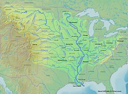
ਮਿੱਸੀਸਿੱਪੀ ਦਰਿਆ ਉੱਤਰੀ ਅਮਰੀਕਾ ਵਿੱਚ ਸਭ ਤੋਂ ਵੱਡੇ ਡਰੇਨੇਜ ਸਿਸਟਮ ਦਾ ਮੁੱਖ ਦਰਿਆ ਹੈ।[3][4]
| ਮਿੱਸੀਸਿੱਪੀ ਦਰਿਆ | |
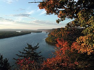
ਮਿੱਸੀਸਿੱਪੀ ਦਰਿਆ ਹਾਰਪਰਸ ਫੈਰੀ, ਇਓਬਾ ਨੇੜੇ
| |
| ਨਾਂ ਦਾ ਸਰੋਤ: Ojibwe word misi-ziibi, meaning "Great River", or gichi-ziibi, meaning "Big River" | |
| ਦੇਸ਼ | ਸੰਯੁਕਤ ਰਾਜ ਅਮਰੀਕਾ |
|---|---|
| ਰਾਜ | Minnesota, Wisconsin, Iowa, Illinois, Missouri, Kentucky, Tennessee, Arkansas, Mississippi, Louisiana |
| ਸਹਾਇਕ ਦਰਿਆ | |
| - ਖੱਬੇ | St. Croix River, Wisconsin River, Rock River, Illinois River, Kaskaskia River, Ohio River |
| - ਸੱਜੇ | Minnesota River, Des Moines River, Missouri River, White River, Arkansas River, Red River |
| ਸ਼ਹਿਰ | Minneapolis, MN, St. Paul, MN, La Crosse, WI, Quad Cities, IA/IL, St. Louis, MO, Memphis, TN, Baton Rouge, LA, New Orleans, LA |
| ਸਰੋਤ | Lake Itasca[1] |
| - ਸਥਿਤੀ | Itasca State Park, Clearwater County, MN |
| - ਉਚਾਈ | 1,475 ਫੁੱਟ (450 ਮੀਟਰ) |
| - ਦਿਸ਼ਾ-ਰੇਖਾਵਾਂ | 47°14′23″N 95°12′27″W / 47.23972°N 95.20750°W |
| ਦਹਾਨਾ | ਮੈਕਸੀਕੋ ਦੀ ਖਾੜੀ |
| - ਸਥਿਤੀ | Pilottown, Plaquemines Parish, LA |
| - ਉਚਾਈ | 0 ਫੁੱਟ (0 ਮੀਟਰ) |
| - ਦਿਸ਼ਾ-ਰੇਖਾਵਾਂ | 29°09′04″N 89°15′12″W / 29.15111°N 89.25333°W |
| ਲੰਬਾਈ | 2,340 ਮੀਲ (3,766 ਕਿਮੀ) |
| ਬੇਟ | 11,51,000 ਵਰਗ ਮੀਲ (29,81,076 ਕਿਮੀ੨) |
| ਡਿਗਾਊ ਜਲ-ਮਾਤਰਾ | mouth; max and min at Baton Rouge, LA |
| - ਔਸਤ | 5,93,000 ਘਣ ਫੁੱਟ/ਸ (16,792 ਮੀਟਰ੩/ਸ) [2] |
| - ਵੱਧ ਤੋਂ ਵੱਧ | 30,65,000 ਘਣ ਫੁੱਟ/ਸ (86,791 ਮੀਟਰ੩/ਸ) |
| - ਘੱਟੋ-ਘੱਟ | 1,59,000 ਘਣ ਫੁੱਟ/ਸ (4,502 ਮੀਟਰ੩/ਸ) |
ਹਵਾਲੇ
ਸੋਧੋ- ↑ The United States Geological Survey recognizes two contrasting definitions of a river's source.USGS.gov By the stricter definition, the Mississippi would share its source with its longest tributary, the Missouri, at Brower's Spring in Montana. The other definition acknowledges "somewhat arbitrary decisions" and places the Mississippi's source at Lake Itasca, which is publicly accepted as the source,USGS.gov and which had been identified as such by Brower himself.MT.gov Archived 2012-01-18 at the Wayback Machine.
- ↑ Kammerer, J.C. (May 1990). "ਸੰਯੁਕਤ ਰਾਜ ਅਮਰੀਕਾ ਦੇ ਸਭ ਤੋਂ ਵੱਡੇ ਦਰਿਆ". ਯੂ ਐਸ ਭੂਗੋਲਿਕ ਸਰਵੇ. Retrieved 22 ਫਰਵਰੀ 2011.
{{cite web}}: Check date values in:|accessdate=(help) - ↑ United States Geological Survey Hydrological Unit Code: 08-09-01-00- Lower Mississippi-New Orleans Watershed
- ↑ "Lengths of the major rivers". United States Geological Survey. Archived from the original on ਮਾਰਚ 5, 2009. Retrieved March 14, 2009.
{{cite web}}: Unknown parameter|dead-url=ignored (|url-status=suggested) (help)
| ਇਹ ਲੇਖ ਅਧਾਰ ਹੈ। ਤੁਸੀਂ ਇਸਨੂੰ ਵਧਾਕੇ ਵਿਕੀਪੀਡੀਆ ਦੀ ਮੱਦਦ ਕਰ ਸਕਦੇ ਹੋ। |

