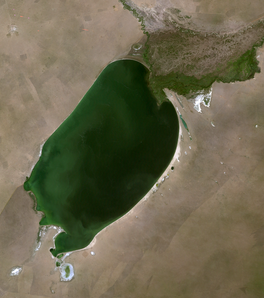
ਬੁਇਰ ਝੀਲ
ਬੁਇਰ ਝੀਲ ( Mongolian: Буйр нуур, romanized: Buyır nağur; Chinese: 贝尔湖; pinyin: Bèi'ěr Hú ) ਇੱਕ ਤਾਜ਼ੇ ਪਾਣੀ ਦੀ ਝੀਲ ਹੈ ਜੋ ਮੰਗੋਲੀਆ ਅਤੇ ਚੀਨ ਦੀ ਸਰਹੱਦ 'ਤੇ ਫੈਲੀ ਹੋਈ ਹੈ। ਇਹ ਬੁਇਰ ਝੀਲ ਡਿਪਰੈਸ਼ਨ ਦੇ ਅੰਦਰ ਸਥਿਤ ਹੈ। ਚੀਨੀ ਸ਼ਹਿਰ ਹੁਲੁਨਬੁਇਰ ਦਾ ਨਾਂ ਇਸ ਝੀਲ ਅਤੇ ਹੁਲੁਨ ਝੀਲ ਦੋਵਾਂ ਦੇ ਨਾਂ 'ਤੇ ਰੱਖਿਆ ਗਿਆ ਹੈ, ਜੋ ਕਿ ਅੰਦਰੂਨੀ ਮੰਗੋਲੀਆ ਦੀ ਸਰਹੱਦ ਦੇ ਚੀਨੀ ਪਾਸੇ ਪੂਰੀ ਤਰ੍ਹਾਂ ਸਥਿਤ ਹੈ।[2]
| ਬੁਇਰ ਝੀਲ | |
|---|---|
 Satellite image of Buir Lake | |
| Lua error in ਮੌਡਿਊਲ:Location_map at line 522: Unable to find the specified location map definition: "Module:Location map/data/Mongolia" does not exist. | |
| ਸਥਿਤੀ | ਡੋਰਨੋਡ ਪ੍ਰਾਂਤ, ਮੰਗੋਲੀਆ ਅਤੇ ਹੁਲੁਨਬੇਇਰ, ਚੀਨ |
| ਗੁਣਕ | 47°48′25″N 117°41′32″E / 47.80694°N 117.69222°E |
| ਅਧਿਕਾਰਤ ਨਾਮ | Lake Buir and its surrounding wetlands |
| ਅਹੁਦਾ | 22 March 2004 |
| ਹਵਾਲਾ ਨੰ. | 1377[1] |
1388 ਵਿੱਚ, ਲੈਨ ਯੂ ਦੇ ਅਧੀਨ ਮਿੰਗ ਫੌਜਾਂ ਨੇ ਬੁਇਰ ਝੀਲ ਖੇਤਰ ਉੱਤੇ ਉੱਤਰੀ ਯੁਆਨ ਉੱਤੇ ਇੱਕ ਵੱਡੀ ਜਿੱਤ ਪ੍ਰਾਪਤ ਕੀਤੀ। ਉੱਤਰੀ ਯੁਆਨ ਸ਼ਾਸਕ ਟੋਗੁਸ ਟੇਮੂਰ ਨੇ ਭੱਜਣ ਦੀ ਕੋਸ਼ਿਸ਼ ਕੀਤੀ ਪਰ ਥੋੜ੍ਹੀ ਦੇਰ ਬਾਅਦ ਮਾਰਿਆ ਗਿਆ।[3]
ਹਵਾਲੇ
ਸੋਧੋ- ↑ "Lake Buir and its surrounding wetlands". Ramsar Sites Information Service. Retrieved 25 April 2018.
- ↑ "Translations on People's Republic of China", by United States Joint Publications Research Service
- ↑ The Mongol empire & its legacy, by Reuven Amitai-Preiss, David Morgan, pg 293